You are here: Home > Network List > NN - Western Great Basin/Eastern Sierra Nevada Stations List
> Station UNVG UNLV greenhouse area, Las Vegas Valley > Earthquake Result Viewer
UNVG UNLV greenhouse area, Las Vegas Valley - Earthquake Result Viewer
| Earthquake location: |
Northwest Of Kuril Islands |
| Earthquake latitude/longitude: |
52.7/153.7 |
| Earthquake time(UTC): |
2018/10/13 (286) 11:10:19 GMT |
| Earthquake Depth: |
397 km |
| Earthquake Magnitude: |
6.7 Mi |
| Earthquake Catalog/Contributor: |
NEIC PDE/pt |
|
| Network: |
NN Western Great Basin/Eastern Sierra Nevada |
| Station: |
UNVG UNLV greenhouse area, Las Vegas Valley |
| Lat/Lon: |
36.11 N/115.14 W |
| Elevation: |
619 m |
|
| Distance: |
62.9 deg |
| Az: |
65.418 deg |
| Baz: |
316.886 deg |
| Ray Param: |
0.058563713 |
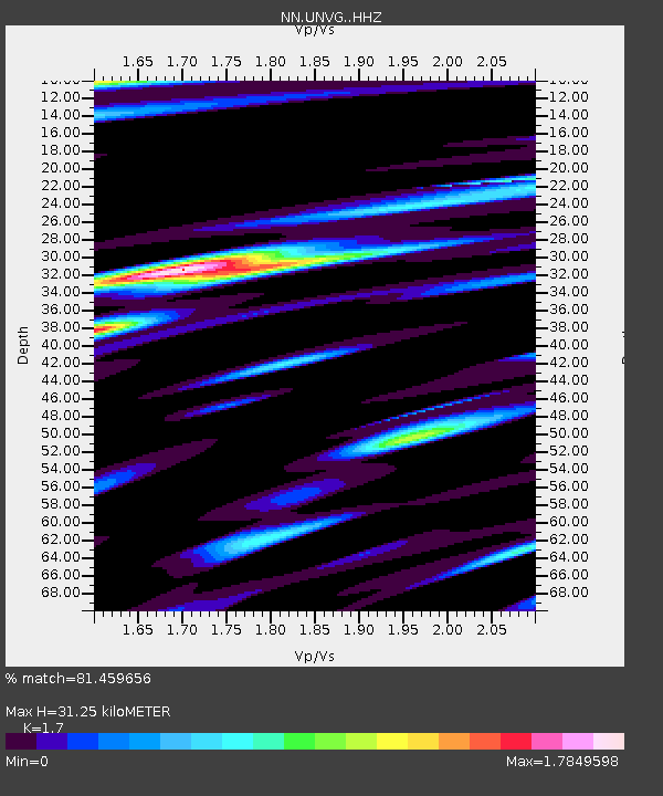
| Estimated Moho Depth: |
31.25 km |
| Estimated Crust Vp/Vs: |
1.70 |
| Assumed Crust Vp: |
6.276 km/s |
| Estimated Crust Vs: |
3.692 km/s |
| Estimated Crust Poisson's Ratio: |
0.24 |
|
| Radial Match: |
81.459656 % |
| Radial Bump: |
400 |
| Transverse Match: |
71.62446 % |
| Transverse Bump: |
400 |
| SOD ConfigId: |
13570011 |
| Insert Time: |
2019-05-01 12:45:35.582 +0000 |
| GWidth: |
2.5 |
| Max Bumps: |
400 |
| Tol: |
0.001 |
|

Signal To Noise
| Channel | StoN | STA | LTA |
| NN:UNVG: :HHZ:20181013T11:19:32.669983Z | 45.151684 | 9.994702E-6 | 2.2135835E-7 |
| NN:UNVG: :HHN:20181013T11:19:32.669983Z | 18.189812 | 3.9864944E-6 | 2.1916084E-7 |
| NN:UNVG: :HHE:20181013T11:19:32.669983Z | 12.616675 | 2.799146E-6 | 2.218608E-7 |
| Arrivals |
| Ps | 3.6 SECOND |
| PpPs | 13 SECOND |
| PsPs/PpSs | 17 SECOND |


