You are here: Home > Network List > PY - PFO Array Stations List
> Station BPH05 Pinon Flat Observatory, CA, USA > Earthquake Result Viewer
BPH05 Pinon Flat Observatory, CA, USA - Earthquake Result Viewer
| Earthquake location: |
Northwest Of Kuril Islands |
| Earthquake latitude/longitude: |
52.7/153.7 |
| Earthquake time(UTC): |
2018/10/13 (286) 11:10:19 GMT |
| Earthquake Depth: |
397 km |
| Earthquake Magnitude: |
6.7 Mi |
| Earthquake Catalog/Contributor: |
NEIC PDE/pt |
|
| Network: |
PY PFO Array |
| Station: |
BPH05 Pinon Flat Observatory, CA, USA |
| Lat/Lon: |
33.61 N/116.46 W |
| Elevation: |
1302 m |
|
| Distance: |
64.0 deg |
| Az: |
68.197 deg |
| Baz: |
317.382 deg |
| Ray Param: |
0.05786761 |
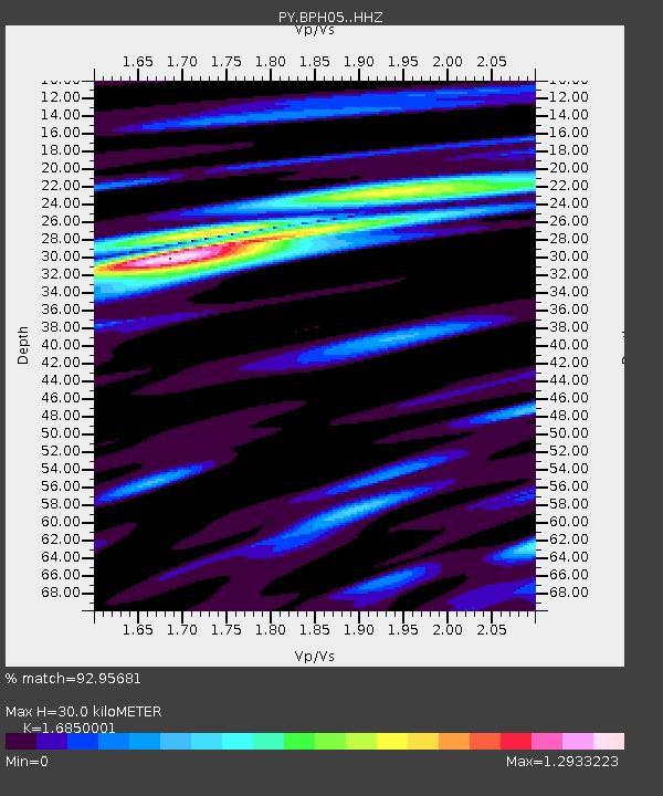
| Estimated Moho Depth: |
30.0 km |
| Estimated Crust Vp/Vs: |
1.69 |
| Assumed Crust Vp: |
6.264 km/s |
| Estimated Crust Vs: |
3.717 km/s |
| Estimated Crust Poisson's Ratio: |
0.23 |
|
| Radial Match: |
92.95681 % |
| Radial Bump: |
400 |
| Transverse Match: |
74.17971 % |
| Transverse Bump: |
400 |
| SOD ConfigId: |
13570011 |
| Insert Time: |
2019-05-01 12:47:26.117 +0000 |
| GWidth: |
2.5 |
| Max Bumps: |
400 |
| Tol: |
0.001 |
|

Signal To Noise
| Channel | StoN | STA | LTA |
| PY:BPH05: :HHZ:20181013T11:19:39.750Z | 40.75804 | 6.793746E-6 | 1.666848E-7 |
| PY:BPH05: :HHN:20181013T11:19:39.750Z | 20.77177 | 2.8784075E-6 | 1.3857304E-7 |
| PY:BPH05: :HHE:20181013T11:19:39.750Z | 12.628717 | 1.8535634E-6 | 1.4677369E-7 |
| Arrivals |
| Ps | 3.4 SECOND |
| PpPs | 12 SECOND |
| PsPs/PpSs | 16 SECOND |


