You are here: Home > Network List > RV - Regional Alberta Seismic Observatory for Earthquake Studies Network Stations List
> Station KIMIA Kimiwan Lookout Tower, AB > Earthquake Result Viewer
KIMIA Kimiwan Lookout Tower, AB - Earthquake Result Viewer
| Earthquake location: |
Northwest Of Kuril Islands |
| Earthquake latitude/longitude: |
52.7/153.7 |
| Earthquake time(UTC): |
2018/10/13 (286) 11:10:19 GMT |
| Earthquake Depth: |
397 km |
| Earthquake Magnitude: |
6.7 Mi |
| Earthquake Catalog/Contributor: |
NEIC PDE/pt |
|
| Network: |
RV Regional Alberta Seismic Observatory for Earthquake Studies Network |
| Station: |
KIMIA Kimiwan Lookout Tower, AB |
| Lat/Lon: |
55.99 N/116.61 W |
| Elevation: |
764 m |
|
| Distance: |
48.8 deg |
| Az: |
48.263 deg |
| Baz: |
306.074 deg |
| Ray Param: |
0.06743897 |
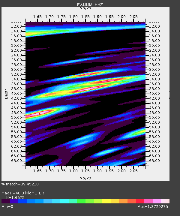
| Estimated Moho Depth: |
48.0 km |
| Estimated Crust Vp/Vs: |
1.66 |
| Assumed Crust Vp: |
6.426 km/s |
| Estimated Crust Vs: |
3.877 km/s |
| Estimated Crust Poisson's Ratio: |
0.21 |
|
| Radial Match: |
89.45218 % |
| Radial Bump: |
400 |
| Transverse Match: |
76.19574 % |
| Transverse Bump: |
400 |
| SOD ConfigId: |
13570011 |
| Insert Time: |
2019-05-01 12:47:44.654 +0000 |
| GWidth: |
2.5 |
| Max Bumps: |
400 |
| Tol: |
0.001 |
|

Signal To Noise
| Channel | StoN | STA | LTA |
| RV:KIMIA: :HHZ:20181013T11:17:54.519989Z | 97.70121 | 1.7153892E-5 | 1.7557504E-7 |
| RV:KIMIA: :HHN:20181013T11:17:54.519989Z | 12.961705 | 7.7326295E-6 | 5.9657503E-7 |
| RV:KIMIA: :HHE:20181013T11:17:54.519989Z | 17.674881 | 7.986204E-6 | 4.518392E-7 |
| Arrivals |
| Ps | 5.2 SECOND |
| PpPs | 19 SECOND |
| PsPs/PpSs | 24 SECOND |


