You are here: Home > Network List > TS - TERRAscope (Southern California Seismic Network) Stations List
> Station BAR Barrett Dam, California, USA > Earthquake Result Viewer
BAR Barrett Dam, California, USA - Earthquake Result Viewer
| Earthquake location: |
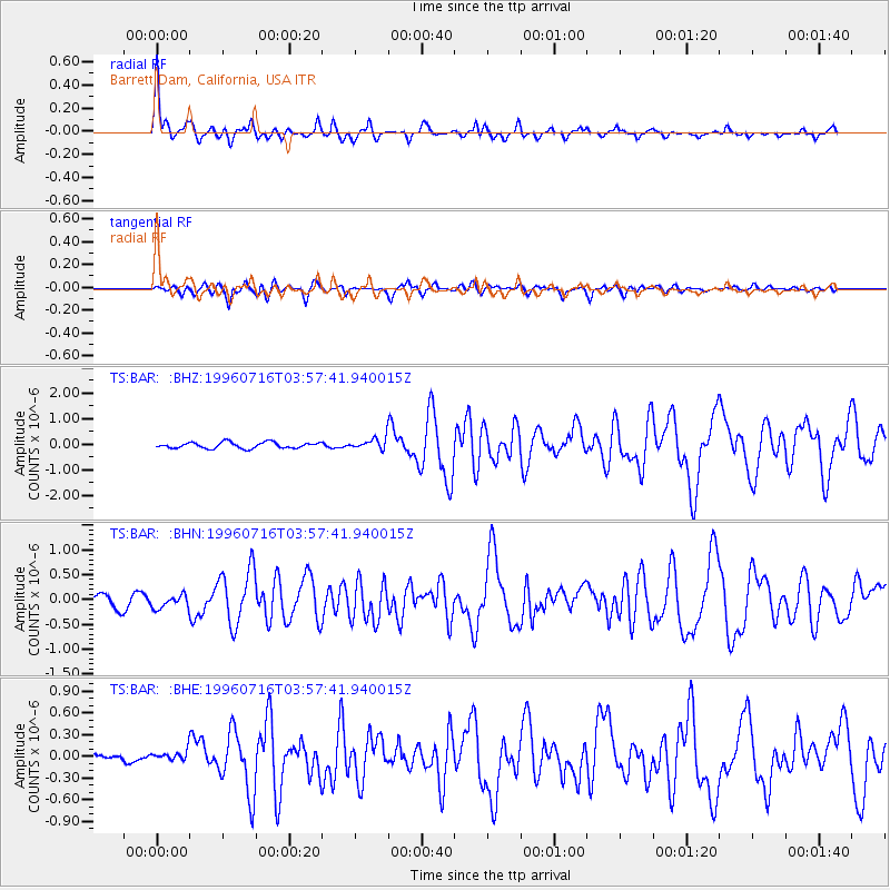
Komandorskiye Ostrova Region |
| Earthquake latitude/longitude: |
56.1/165.0 |
| Earthquake time(UTC): |
1996/07/16 (198) 03:48:28 GMT |
| Earthquake Depth: |
33 km |
| Earthquake Magnitude: |
5.8 MB, 6.4 MS, 6.5 UNKNOWN, 6.3 MW |
| Earthquake Catalog/Contributor: |
WHDF/NEIC |
|
| Network: |
TS TERRAscope (Southern California Seismic Network) |
| Station: |
BAR Barrett Dam, California, USA |
| Lat/Lon: |
32.68 N/116.67 W |
| Elevation: |
548 m |
|
| Distance: |
57.3 deg |
| Az: |
79.038 deg |
| Baz: |
319.265 deg |
| Ray Param: |
0.06353881 |
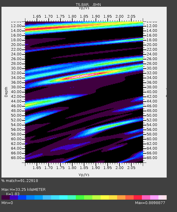
| Estimated Moho Depth: |
33.25 km |
| Estimated Crust Vp/Vs: |
1.83 |
| Assumed Crust Vp: |
6.264 km/s |
| Estimated Crust Vs: |
3.423 km/s |
| Estimated Crust Poisson's Ratio: |
0.29 |
|
| Radial Match: |
91.22918 % |
| Radial Bump: |
304 |
| Transverse Match: |
82.340744 % |
| Transverse Bump: |
400 |
| SOD ConfigId: |
6273 |
| Insert Time: |
2010-02-26 13:58:48.106 +0000 |
| GWidth: |
2.5 |
| Max Bumps: |
400 |
| Tol: |
0.001 |
|
Signal To Noise
| Channel | StoN | STA | LTA |
| TS:BAR: :BHN:19960716T03:57:41.940015Z | 1.3478836 | 1.3736064E-7 | 1.0190839E-7 |
| TS:BAR: :BHE:19960716T03:57:41.940015Z | 0.6542981 | 6.5533506E-8 | 1.0015847E-7 |
| TS:BAR: :BHZ:19960716T03:57:41.940015Z | 1.8712937 | 2.1818758E-7 | 1.1659719E-7 |
| Arrivals |
| Ps | 4.6 SECOND |
| PpPs | 14 SECOND |
| PsPs/PpSs | 19 SECOND |


