You are here: Home > Network List > TA - USArray Transportable Network (new EarthScope stations) Stations List
> Station D25K Kavik River, AK, USA > Earthquake Result Viewer
D25K Kavik River, AK, USA - Earthquake Result Viewer
| Earthquake location: |
Northwest Of Kuril Islands |
| Earthquake latitude/longitude: |
52.7/153.7 |
| Earthquake time(UTC): |
2018/10/13 (286) 11:10:19 GMT |
| Earthquake Depth: |
397 km |
| Earthquake Magnitude: |
6.7 Mi |
| Earthquake Catalog/Contributor: |
NEIC PDE/pt |
|
| Network: |
TA USArray Transportable Network (new EarthScope stations) |
| Station: |
D25K Kavik River, AK, USA |
| Lat/Lon: |
69.32 N/146.38 W |
| Elevation: |
770 m |
|
| Distance: |
31.8 deg |
| Az: |
35.706 deg |
| Baz: |
269.67 deg |
| Ray Param: |
0.077449016 |
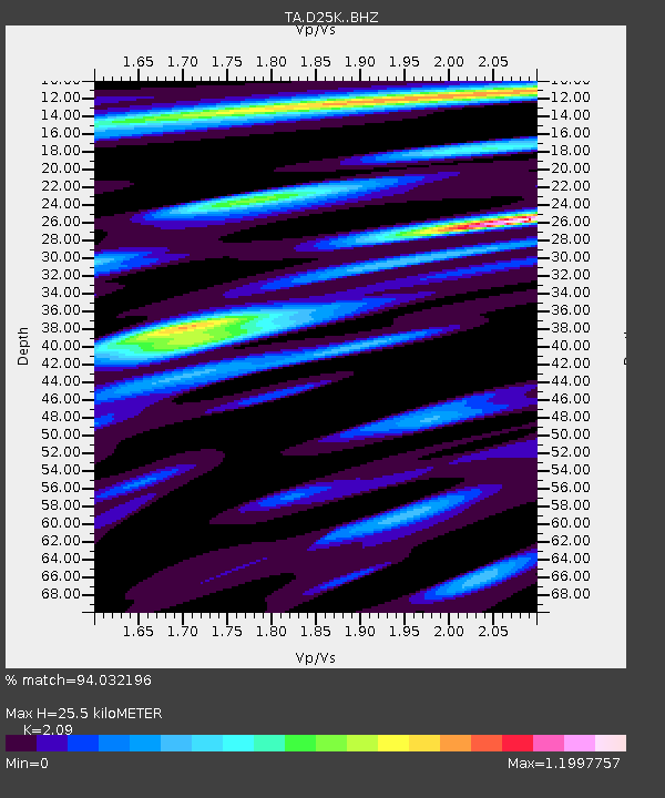
| Estimated Moho Depth: |
25.5 km |
| Estimated Crust Vp/Vs: |
2.09 |
| Assumed Crust Vp: |
6.378 km/s |
| Estimated Crust Vs: |
3.052 km/s |
| Estimated Crust Poisson's Ratio: |
0.35 |
|
| Radial Match: |
94.032196 % |
| Radial Bump: |
400 |
| Transverse Match: |
85.07548 % |
| Transverse Bump: |
400 |
| SOD ConfigId: |
13570011 |
| Insert Time: |
2019-05-01 12:48:22.003 +0000 |
| GWidth: |
2.5 |
| Max Bumps: |
400 |
| Tol: |
0.001 |
|
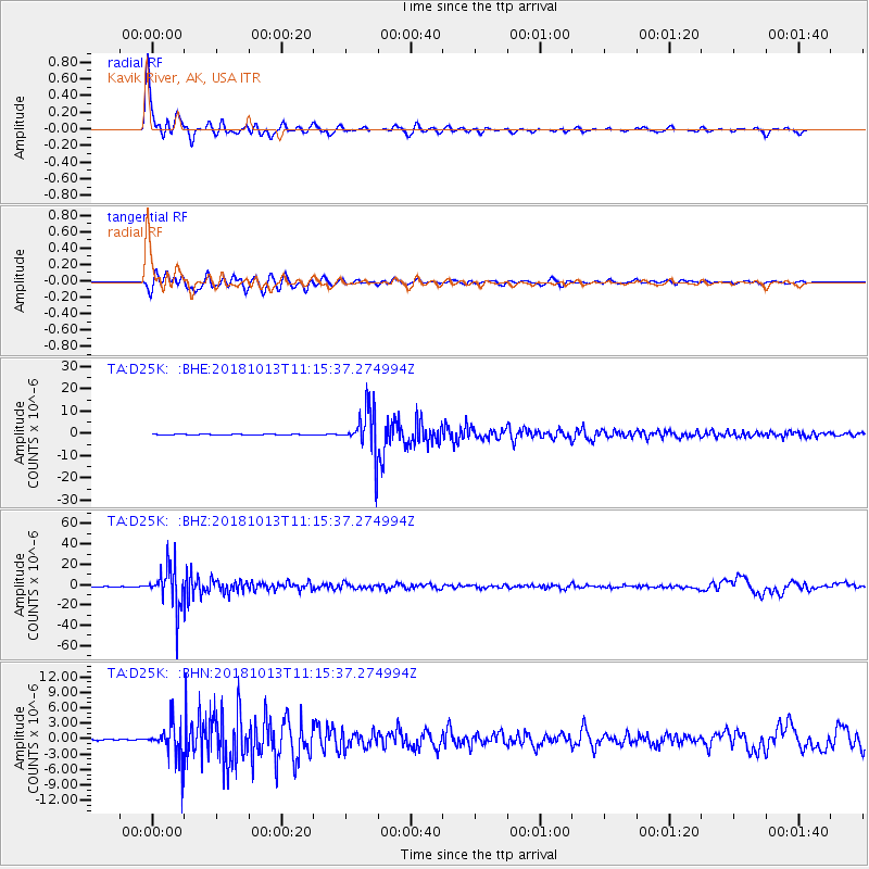
Signal To Noise
| Channel | StoN | STA | LTA |
| TA:D25K: :BHZ:20181013T11:15:37.274994Z | 166.12575 | 2.038243E-5 | 1.2269278E-7 |
| TA:D25K: :BHN:20181013T11:15:37.274994Z | 21.408092 | 3.7622308E-6 | 1.7573872E-7 |
| TA:D25K: :BHE:20181013T11:15:37.274994Z | 83.02186 | 1.138112E-5 | 1.3708582E-7 |
| Arrivals |
| Ps | 4.6 SECOND |
| PpPs | 12 SECOND |
| PsPs/PpSs | 16 SECOND |


