You are here: Home > Network List > TA - USArray Transportable Network (new EarthScope stations) Stations List
> Station H31M Peel River, Yukon, CAN > Earthquake Result Viewer
H31M Peel River, Yukon, CAN - Earthquake Result Viewer
| Earthquake location: |
Northwest Of Kuril Islands |
| Earthquake latitude/longitude: |
52.7/153.7 |
| Earthquake time(UTC): |
2018/10/13 (286) 11:10:19 GMT |
| Earthquake Depth: |
397 km |
| Earthquake Magnitude: |
6.7 Mi |
| Earthquake Catalog/Contributor: |
NEIC PDE/pt |
|
| Network: |
TA USArray Transportable Network (new EarthScope stations) |
| Station: |
H31M Peel River, Yukon, CAN |
| Lat/Lon: |
65.81 N/134.34 W |
| Elevation: |
642 m |
|
| Distance: |
36.8 deg |
| Az: |
40.843 deg |
| Baz: |
285.041 deg |
| Ray Param: |
0.07475194 |
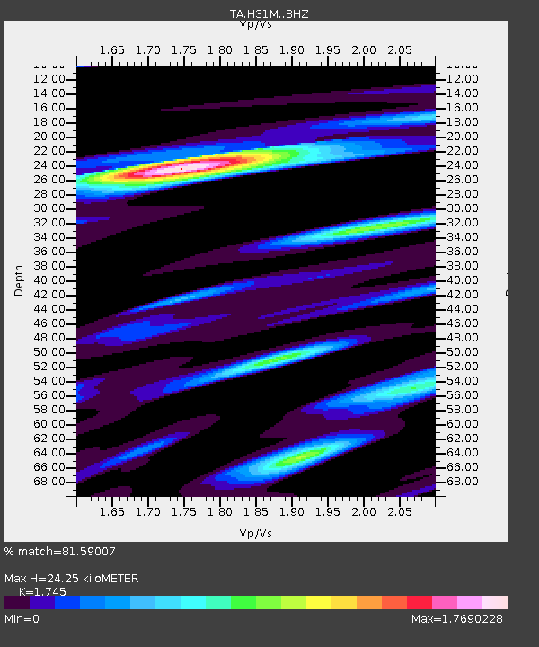
| Estimated Moho Depth: |
24.25 km |
| Estimated Crust Vp/Vs: |
1.75 |
| Assumed Crust Vp: |
6.419 km/s |
| Estimated Crust Vs: |
3.679 km/s |
| Estimated Crust Poisson's Ratio: |
0.26 |
|
| Radial Match: |
81.59007 % |
| Radial Bump: |
400 |
| Transverse Match: |
69.76559 % |
| Transverse Bump: |
400 |
| SOD ConfigId: |
13570011 |
| Insert Time: |
2019-05-01 12:48:44.930 +0000 |
| GWidth: |
2.5 |
| Max Bumps: |
400 |
| Tol: |
0.001 |
|
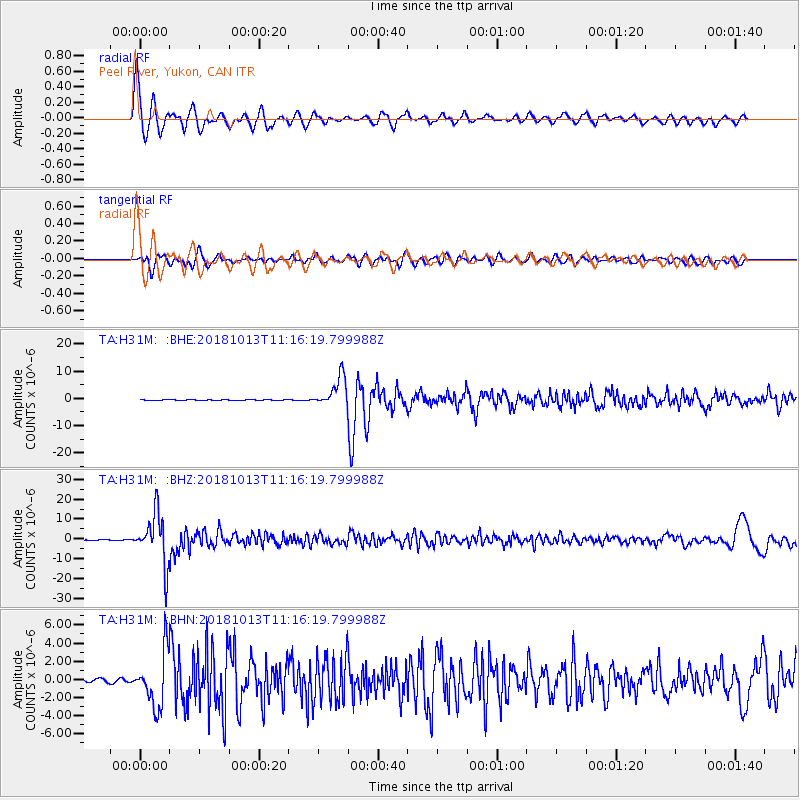
Signal To Noise
| Channel | StoN | STA | LTA |
| TA:H31M: :BHZ:20181013T11:16:19.799988Z | 94.68637 | 1.2943214E-5 | 1.3669563E-7 |
| TA:H31M: :BHN:20181013T11:16:19.799988Z | 12.481468 | 3.0930441E-6 | 2.4781093E-7 |
| TA:H31M: :BHE:20181013T11:16:19.799988Z | 57.74296 | 9.533063E-6 | 1.6509482E-7 |
| Arrivals |
| Ps | 3.0 SECOND |
| PpPs | 9.7 SECOND |
| PsPs/PpSs | 13 SECOND |


