You are here: Home > Network List > TA - USArray Transportable Network (new EarthScope stations) Stations List
> Station L44A Lake County Forest Preserve, Grayslake, IL, USA > Earthquake Result Viewer
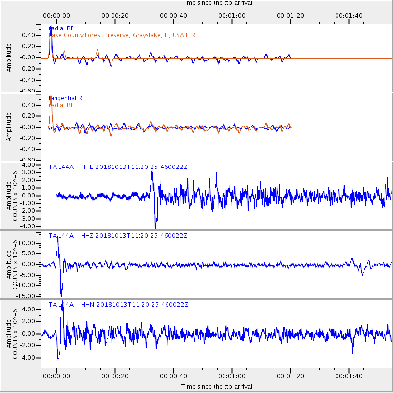
L44A Lake County Forest Preserve, Grayslake, IL, USA - Earthquake Result Viewer
*The percent match for this event was below the threshold and hence no stack was calculated.
| Earthquake location: |
Northwest Of Kuril Islands |
| Earthquake latitude/longitude: |
52.7/153.7 |
| Earthquake time(UTC): |
2018/10/13 (286) 11:10:19 GMT |
| Earthquake Depth: |
397 km |
| Earthquake Magnitude: |
6.7 Mi |
| Earthquake Catalog/Contributor: |
NEIC PDE/pt |
|
| Network: |
TA USArray Transportable Network (new EarthScope stations) |
| Station: |
L44A Lake County Forest Preserve, Grayslake, IL, USA |
| Lat/Lon: |
42.18 N/87.91 W |
| Elevation: |
202 m |
|
| Distance: |
71.6 deg |
| Az: |
43.547 deg |
| Baz: |
325.66 deg |
| Ray Param: |
$rayparam |
*The percent match for this event was below the threshold and hence was not used in the summary stack. |
|
| Radial Match: |
88.01694 % |
| Radial Bump: |
235 |
| Transverse Match: |
58.913727 % |
| Transverse Bump: |
400 |
| SOD ConfigId: |
13570011 |
| Insert Time: |
2019-05-01 12:49:00.057 +0000 |
| GWidth: |
2.5 |
| Max Bumps: |
400 |
| Tol: |
0.001 |
|
Signal To Noise
| Channel | StoN | STA | LTA |
| TA:L44A: :HHZ:20181013T11:20:25.460022Z | 24.002554 | 5.949197E-6 | 2.4785683E-7 |
| TA:L44A: :HHN:20181013T11:20:25.460022Z | 7.3035774 | 2.5238398E-6 | 3.4556214E-7 |
| TA:L44A: :HHE:20181013T11:20:25.460022Z | 7.5635557 | 1.7460869E-6 | 2.308553E-7 |
| Arrivals |
| Ps | |
| PpPs | |
| PsPs/PpSs | |


