You are here: Home > Network List > TA - USArray Transportable Network (new EarthScope stations) Stations List
> Station M29M Somme Creek, YT, CAN > Earthquake Result Viewer
M29M Somme Creek, YT, CAN - Earthquake Result Viewer
| Earthquake location: |
Northwest Of Kuril Islands |
| Earthquake latitude/longitude: |
52.7/153.7 |
| Earthquake time(UTC): |
2018/10/13 (286) 11:10:19 GMT |
| Earthquake Depth: |
397 km |
| Earthquake Magnitude: |
6.7 Mi |
| Earthquake Catalog/Contributor: |
NEIC PDE/pt |
|
| Network: |
TA USArray Transportable Network (new EarthScope stations) |
| Station: |
M29M Somme Creek, YT, CAN |
| Lat/Lon: |
62.44 N/138.46 W |
| Elevation: |
1297 m |
|
| Distance: |
36.0 deg |
| Az: |
47.143 deg |
| Baz: |
286.409 deg |
| Ray Param: |
0.075213574 |
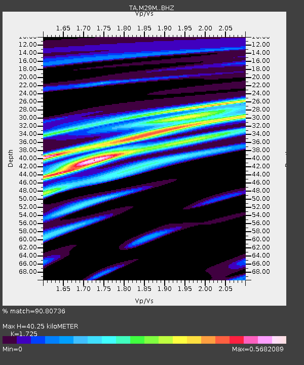
| Estimated Moho Depth: |
40.25 km |
| Estimated Crust Vp/Vs: |
1.73 |
| Assumed Crust Vp: |
6.566 km/s |
| Estimated Crust Vs: |
3.806 km/s |
| Estimated Crust Poisson's Ratio: |
0.25 |
|
| Radial Match: |
90.80736 % |
| Radial Bump: |
400 |
| Transverse Match: |
64.69016 % |
| Transverse Bump: |
400 |
| SOD ConfigId: |
13570011 |
| Insert Time: |
2019-05-01 12:49:05.936 +0000 |
| GWidth: |
2.5 |
| Max Bumps: |
400 |
| Tol: |
0.001 |
|

Signal To Noise
| Channel | StoN | STA | LTA |
| TA:M29M: :BHZ:20181013T11:16:13.225006Z | 49.03477 | 9.084873E-6 | 1.8527412E-7 |
| TA:M29M: :BHN:20181013T11:16:13.225006Z | 9.067648 | 1.3374066E-6 | 1.4749212E-7 |
| TA:M29M: :BHE:20181013T11:16:13.225006Z | 38.78732 | 5.5494224E-6 | 1.4307311E-7 |
| Arrivals |
| Ps | 4.8 SECOND |
| PpPs | 15 SECOND |
| PsPs/PpSs | 20 SECOND |


