You are here: Home > Network List > TA - USArray Transportable Network (new EarthScope stations) Stations List
> Station N31M Braeburn, Yukon, CA > Earthquake Result Viewer
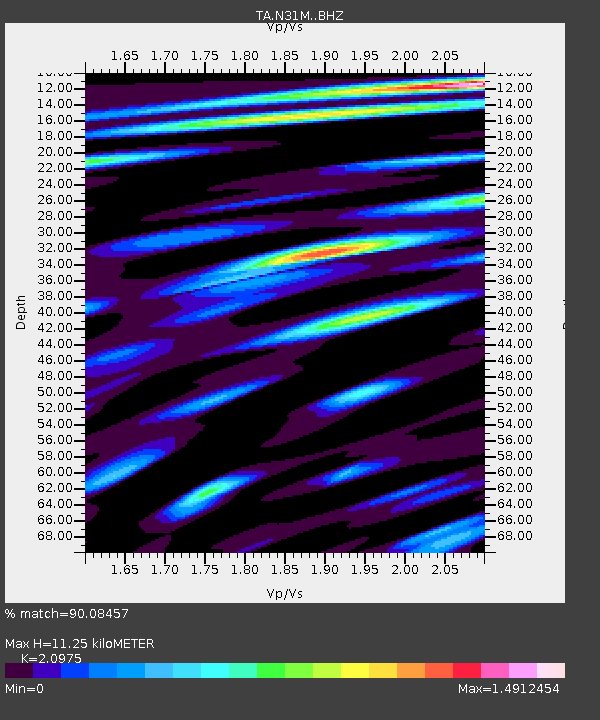
N31M Braeburn, Yukon, CA - Earthquake Result Viewer
| Earthquake location: |
Northwest Of Kuril Islands |
| Earthquake latitude/longitude: |
52.7/153.7 |
| Earthquake time(UTC): |
2018/10/13 (286) 11:10:19 GMT |
| Earthquake Depth: |
397 km |
| Earthquake Magnitude: |
6.7 Mi |
| Earthquake Catalog/Contributor: |
NEIC PDE/pt |
|
| Network: |
TA USArray Transportable Network (new EarthScope stations) |
| Station: |
N31M Braeburn, Yukon, CA |
| Lat/Lon: |
61.49 N/135.78 W |
| Elevation: |
716 m |
|
| Distance: |
37.5 deg |
| Az: |
48.018 deg |
| Baz: |
289.475 deg |
| Ray Param: |
0.07437564 |
| Estimated Moho Depth: |
11.25 km |
| Estimated Crust Vp/Vs: |
2.10 |
| Assumed Crust Vp: |
6.419 km/s |
| Estimated Crust Vs: |
3.06 km/s |
| Estimated Crust Poisson's Ratio: |
0.35 |
|
| Radial Match: |
90.08457 % |
| Radial Bump: |
400 |
| Transverse Match: |
82.63834 % |
| Transverse Bump: |
400 |
| SOD ConfigId: |
13570011 |
| Insert Time: |
2019-05-01 12:49:10.484 +0000 |
| GWidth: |
2.5 |
| Max Bumps: |
400 |
| Tol: |
0.001 |
|

Signal To Noise
| Channel | StoN | STA | LTA |
| TA:N31M: :BHZ:20181013T11:16:25.674988Z | 82.94936 | 1.7478213E-5 | 2.1070942E-7 |
| TA:N31M: :BHN:20181013T11:16:25.674988Z | 11.114745 | 2.7405626E-6 | 2.4657E-7 |
| TA:N31M: :BHE:20181013T11:16:25.674988Z | 33.1381 | 7.786717E-6 | 2.3497778E-7 |
| Arrivals |
| Ps | 2.0 SECOND |
| PpPs | 5.1 SECOND |
| PsPs/PpSs | 7.2 SECOND |


