You are here: Home > Network List > TA - USArray Transportable Network (new EarthScope stations) Stations List
> Station R32K Eaglecrest, AK, USA > Earthquake Result Viewer
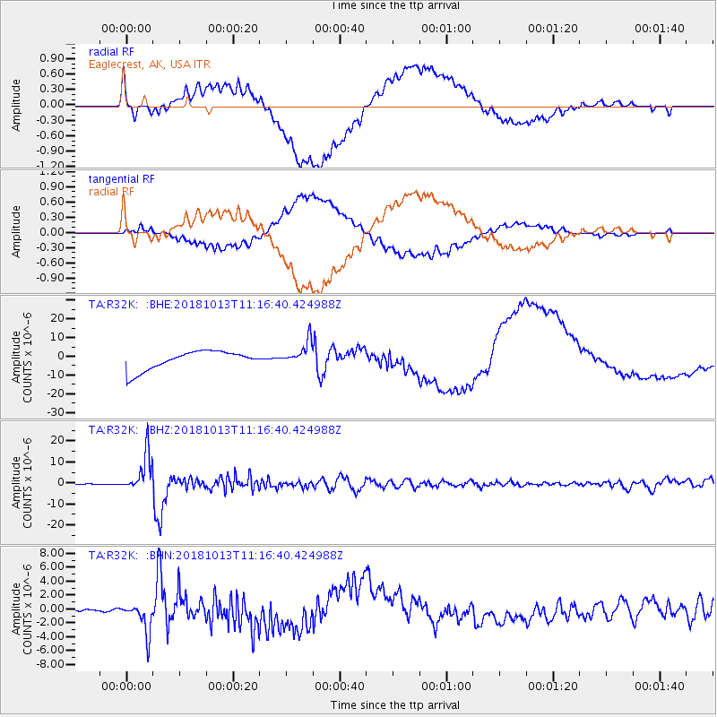
R32K Eaglecrest, AK, USA - Earthquake Result Viewer
*The percent match for this event was below the threshold and hence no stack was calculated.
| Earthquake location: |
Northwest Of Kuril Islands |
| Earthquake latitude/longitude: |
52.7/153.7 |
| Earthquake time(UTC): |
2018/10/13 (286) 11:10:19 GMT |
| Earthquake Depth: |
397 km |
| Earthquake Magnitude: |
6.7 Mi |
| Earthquake Catalog/Contributor: |
NEIC PDE/pt |
|
| Network: |
TA USArray Transportable Network (new EarthScope stations) |
| Station: |
R32K Eaglecrest, AK, USA |
| Lat/Lon: |
58.27 N/134.52 W |
| Elevation: |
386 m |
|
| Distance: |
39.3 deg |
| Az: |
52.457 deg |
| Baz: |
294.045 deg |
| Ray Param: |
$rayparam |
*The percent match for this event was below the threshold and hence was not used in the summary stack. |
|
| Radial Match: |
39.70096 % |
| Radial Bump: |
400 |
| Transverse Match: |
39.240223 % |
| Transverse Bump: |
400 |
| SOD ConfigId: |
13570011 |
| Insert Time: |
2019-05-01 12:49:23.914 +0000 |
| GWidth: |
2.5 |
| Max Bumps: |
400 |
| Tol: |
0.001 |
|
Signal To Noise
| Channel | StoN | STA | LTA |
| TA:R32K: :BHZ:20181013T11:16:40.424988Z | 51.28643 | 9.153603E-6 | 1.7848002E-7 |
| TA:R32K: :BHN:20181013T11:16:40.424988Z | 6.2590065 | 2.2147212E-6 | 3.538455E-7 |
| TA:R32K: :BHE:20181013T11:16:40.424988Z | 1.4332026 | 6.822288E-6 | 4.7601698E-6 |
| Arrivals |
| Ps | |
| PpPs | |
| PsPs/PpSs | |


