You are here: Home > Network List > TA - USArray Transportable Network (new EarthScope stations) Stations List
> Station U33K Whale Pass, AK, USA > Earthquake Result Viewer
U33K Whale Pass, AK, USA - Earthquake Result Viewer
| Earthquake location: |
Northwest Of Kuril Islands |
| Earthquake latitude/longitude: |
52.7/153.7 |
| Earthquake time(UTC): |
2018/10/13 (286) 11:10:19 GMT |
| Earthquake Depth: |
397 km |
| Earthquake Magnitude: |
6.7 Mi |
| Earthquake Catalog/Contributor: |
NEIC PDE/pt |
|
| Network: |
TA USArray Transportable Network (new EarthScope stations) |
| Station: |
U33K Whale Pass, AK, USA |
| Lat/Lon: |
56.11 N/133.12 W |
| Elevation: |
11 m |
|
| Distance: |
40.9 deg |
| Az: |
54.98 deg |
| Baz: |
297.148 deg |
| Ray Param: |
0.07234612 |
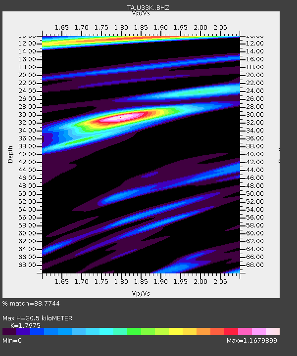
| Estimated Moho Depth: |
30.5 km |
| Estimated Crust Vp/Vs: |
1.80 |
| Assumed Crust Vp: |
6.597 km/s |
| Estimated Crust Vs: |
3.67 km/s |
| Estimated Crust Poisson's Ratio: |
0.28 |
|
| Radial Match: |
88.7744 % |
| Radial Bump: |
400 |
| Transverse Match: |
62.9769 % |
| Transverse Bump: |
400 |
| SOD ConfigId: |
13570011 |
| Insert Time: |
2019-05-01 12:49:33.717 +0000 |
| GWidth: |
2.5 |
| Max Bumps: |
400 |
| Tol: |
0.001 |
|

Signal To Noise
| Channel | StoN | STA | LTA |
| TA:U33K: :BHZ:20181013T11:16:53.549988Z | 50.06314 | 9.594945E-6 | 1.9165688E-7 |
| TA:U33K: :BHN:20181013T11:16:53.549988Z | 18.503628 | 2.804266E-6 | 1.5155223E-7 |
| TA:U33K: :BHE:20181013T11:16:53.549988Z | 33.6564 | 4.79426E-6 | 1.4244719E-7 |
| Arrivals |
| Ps | 3.9 SECOND |
| PpPs | 12 SECOND |
| PsPs/PpSs | 16 SECOND |


