You are here: Home > Network List > TD - TransAlta Monitoring Network Stations List
> Station TD002 TransAlta, Keephills Station 2 > Earthquake Result Viewer
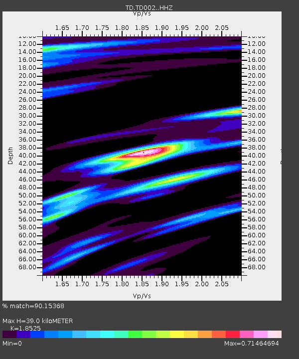
TD002 TransAlta, Keephills Station 2 - Earthquake Result Viewer
| Earthquake location: |
Northwest Of Kuril Islands |
| Earthquake latitude/longitude: |
52.7/153.7 |
| Earthquake time(UTC): |
2018/10/13 (286) 11:10:19 GMT |
| Earthquake Depth: |
397 km |
| Earthquake Magnitude: |
6.7 Mi |
| Earthquake Catalog/Contributor: |
NEIC PDE/pt |
|
| Network: |
TD TransAlta Monitoring Network |
| Station: |
TD002 TransAlta, Keephills Station 2 |
| Lat/Lon: |
53.44 N/114.39 W |
| Elevation: |
739 m |
|
| Distance: |
51.4 deg |
| Az: |
49.887 deg |
| Baz: |
308.923 deg |
| Ray Param: |
0.06579941 |
| Estimated Moho Depth: |
39.0 km |
| Estimated Crust Vp/Vs: |
1.85 |
| Assumed Crust Vp: |
6.426 km/s |
| Estimated Crust Vs: |
3.469 km/s |
| Estimated Crust Poisson's Ratio: |
0.29 |
|
| Radial Match: |
90.15368 % |
| Radial Bump: |
284 |
| Transverse Match: |
61.70942 % |
| Transverse Bump: |
400 |
| SOD ConfigId: |
13570011 |
| Insert Time: |
2019-05-01 12:49:35.332 +0000 |
| GWidth: |
2.5 |
| Max Bumps: |
400 |
| Tol: |
0.001 |
|

Signal To Noise
| Channel | StoN | STA | LTA |
| TD:TD002: :HHZ:20181013T11:18:13.529999Z | 79.961075 | 1.5599719E-5 | 1.9509142E-7 |
| TD:TD002: :HH1:20181013T11:18:13.529999Z | 4.615814 | 1.9958834E-6 | 4.3240115E-7 |
| TD:TD002: :HH2:20181013T11:18:13.529999Z | 16.086893 | 6.813905E-6 | 4.2356876E-7 |
| Arrivals |
| Ps | 5.4 SECOND |
| PpPs | 16 SECOND |
| PsPs/PpSs | 22 SECOND |


