You are here: Home > Network List > TJ - Tajikistan National Seismic Network Stations List
> Station GARM Garm, Tajikistan > Earthquake Result Viewer
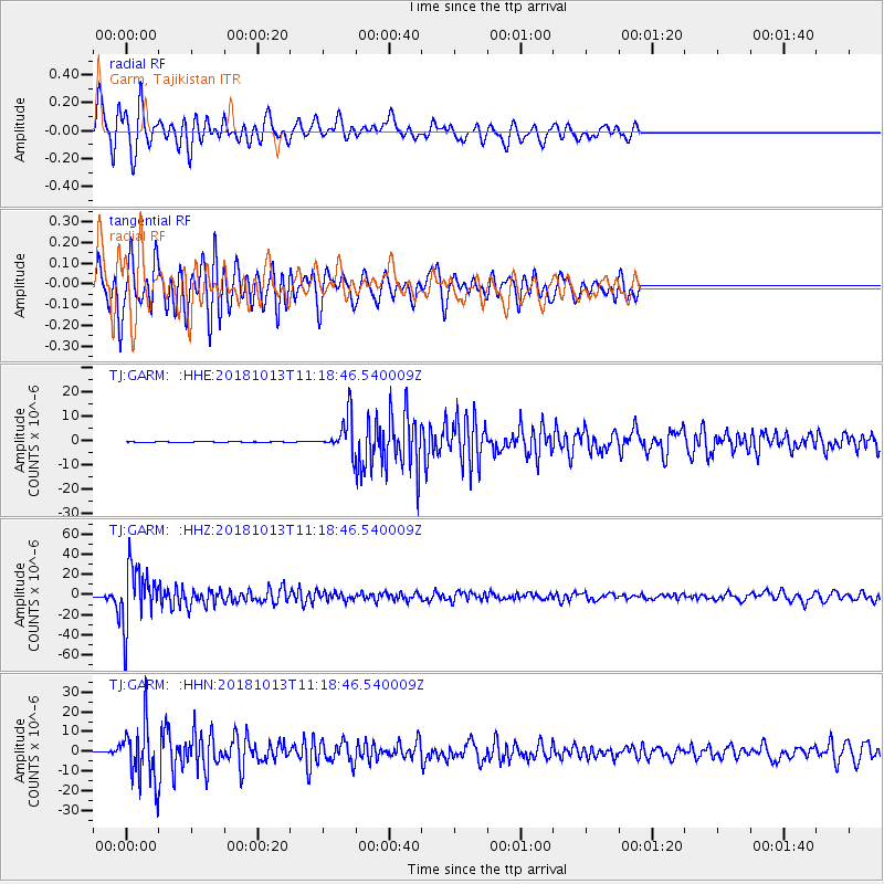
GARM Garm, Tajikistan - Earthquake Result Viewer
*The percent match for this event was below the threshold and hence no stack was calculated.
| Earthquake location: |
Northwest Of Kuril Islands |
| Earthquake latitude/longitude: |
52.7/153.7 |
| Earthquake time(UTC): |
2018/10/13 (286) 11:10:19 GMT |
| Earthquake Depth: |
397 km |
| Earthquake Magnitude: |
6.7 Mi |
| Earthquake Catalog/Contributor: |
NEIC PDE/pt |
|
| Network: |
TJ Tajikistan National Seismic Network |
| Station: |
GARM Garm, Tajikistan |
| Lat/Lon: |
39.00 N/70.32 E |
| Elevation: |
1305 m |
|
| Distance: |
56.5 deg |
| Az: |
291.823 deg |
| Baz: |
46.474 deg |
| Ray Param: |
$rayparam |
*The percent match for this event was below the threshold and hence was not used in the summary stack. |
|
| Radial Match: |
85.44318 % |
| Radial Bump: |
400 |
| Transverse Match: |
83.144424 % |
| Transverse Bump: |
400 |
| SOD ConfigId: |
13570011 |
| Insert Time: |
2019-05-01 12:49:44.644 +0000 |
| GWidth: |
2.5 |
| Max Bumps: |
400 |
| Tol: |
0.001 |
|
Signal To Noise
| Channel | StoN | STA | LTA |
| TJ:GARM: :HHZ:20181013T11:18:46.540009Z | 249.04097 | 2.930661E-5 | 1.1767787E-7 |
| TJ:GARM: :HHN:20181013T11:18:46.540009Z | 176.94562 | 1.4426481E-5 | 8.1530594E-8 |
| TJ:GARM: :HHE:20181013T11:18:46.540009Z | 80.61365 | 1.0983718E-5 | 1.3625136E-7 |
| Arrivals |
| Ps | |
| PpPs | |
| PsPs/PpSs | |


