You are here: Home > Network List > TA - USArray Transportable Network (new EarthScope stations) Stations List
> Station Z21A St. Cloud Mine, Winston, NM, USA > Earthquake Result Viewer
Z21A St. Cloud Mine, Winston, NM, USA - Earthquake Result Viewer
| Earthquake location: |
Tonga Islands |
| Earthquake latitude/longitude: |
-15.1/-173.5 |
| Earthquake time(UTC): |
2008/08/19 (232) 16:30:13 GMT |
| Earthquake Depth: |
8.0 km |
| Earthquake Magnitude: |
5.6 MB, 5.9 MS, 6.1 MW, 6.0 MW |
| Earthquake Catalog/Contributor: |
WHDF/NEIC |
|
| Network: |
TA USArray Transportable Network (new EarthScope stations) |
| Station: |
Z21A St. Cloud Mine, Winston, NM, USA |
| Lat/Lon: |
33.31 N/107.67 W |
| Elevation: |
1964 m |
|
| Distance: |
79.0 deg |
| Az: |
51.082 deg |
| Baz: |
243.83 deg |
| Ray Param: |
0.049238544 |
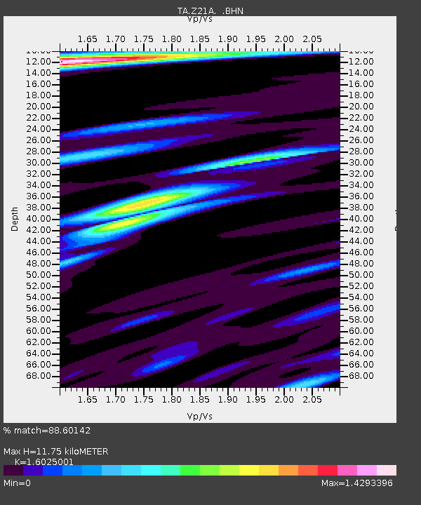
| Estimated Moho Depth: |
11.75 km |
| Estimated Crust Vp/Vs: |
1.60 |
| Assumed Crust Vp: |
6.502 km/s |
| Estimated Crust Vs: |
4.057 km/s |
| Estimated Crust Poisson's Ratio: |
0.18 |
|
| Radial Match: |
88.60142 % |
| Radial Bump: |
400 |
| Transverse Match: |
80.83243 % |
| Transverse Bump: |
400 |
| SOD ConfigId: |
2504 |
| Insert Time: |
2010-03-06 16:53:40.325 +0000 |
| GWidth: |
2.5 |
| Max Bumps: |
400 |
| Tol: |
0.001 |
|
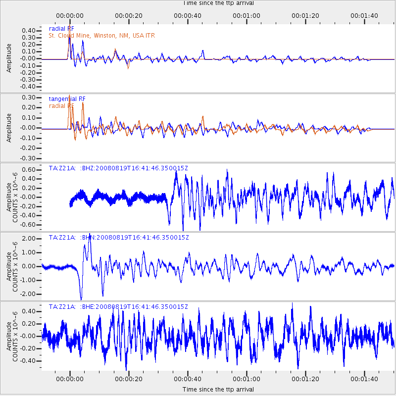
Signal To Noise
| Channel | StoN | STA | LTA |
| TA:Z21A: :BHN:20080819T16:41:46.350015Z | 11.391166 | 8.8662165E-7 | 7.7834144E-8 |
| TA:Z21A: :BHE:20080819T16:41:46.350015Z | 1.4004012 | 1.2869265E-7 | 9.1896986E-8 |
| TA:Z21A: :BHZ:20080819T16:41:46.350015Z | 2.3867722 | 1.9804631E-7 | 8.2976634E-8 |
| Arrivals |
| Ps | 1.1 SECOND |
| PpPs | 4.5 SECOND |
| PsPs/PpSs | 5.7 SECOND |


