You are here: Home > Network List > UW - Pacific Northwest Regional Seismic Network Stations List
> Station LTY Liberty (broad-band) > Earthquake Result Viewer
LTY Liberty (broad-band) - Earthquake Result Viewer
| Earthquake location: |
Northwest Of Kuril Islands |
| Earthquake latitude/longitude: |
52.7/153.7 |
| Earthquake time(UTC): |
2018/10/13 (286) 11:10:19 GMT |
| Earthquake Depth: |
397 km |
| Earthquake Magnitude: |
6.7 Mi |
| Earthquake Catalog/Contributor: |
NEIC PDE/pt |
|
| Network: |
UW Pacific Northwest Regional Seismic Network |
| Station: |
LTY Liberty (broad-band) |
| Lat/Lon: |
47.26 N/120.66 W |
| Elevation: |
970 m |
|
| Distance: |
52.2 deg |
| Az: |
59.215 deg |
| Baz: |
309.866 deg |
| Ray Param: |
0.065299034 |
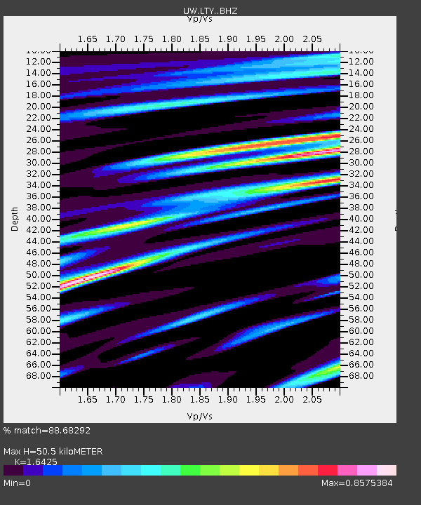
| Estimated Moho Depth: |
50.5 km |
| Estimated Crust Vp/Vs: |
1.64 |
| Assumed Crust Vp: |
6.597 km/s |
| Estimated Crust Vs: |
4.017 km/s |
| Estimated Crust Poisson's Ratio: |
0.21 |
|
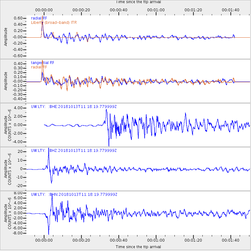
| Radial Match: |
88.68292 % |
| Radial Bump: |
400 |
| Transverse Match: |
75.0191 % |
| Transverse Bump: |
400 |
| SOD ConfigId: |
13570011 |
| Insert Time: |
2019-05-01 12:51:05.983 +0000 |
| GWidth: |
2.5 |
| Max Bumps: |
400 |
| Tol: |
0.001 |
|
Signal To Noise
| Channel | StoN | STA | LTA |
| UW:LTY: :BHZ:20181013T11:18:19.779999Z | 63.739223 | 8.190937E-6 | 1.28507E-7 |
| UW:LTY: :BHN:20181013T11:18:19.779999Z | 31.514196 | 3.1902855E-6 | 1.0123328E-7 |
| UW:LTY: :BHE:20181013T11:18:19.779999Z | 13.669575 | 1.8465865E-6 | 1.3508735E-7 |
| Arrivals |
| Ps | 5.2 SECOND |
| PpPs | 19 SECOND |
| PsPs/PpSs | 24 SECOND |


