You are here: Home > Network List > UW - Pacific Northwest Regional Seismic Network Stations List
> Station RATT Rattlesnake Lake, WA > Earthquake Result Viewer
RATT Rattlesnake Lake, WA - Earthquake Result Viewer
| Earthquake location: |
Northwest Of Kuril Islands |
| Earthquake latitude/longitude: |
52.7/153.7 |
| Earthquake time(UTC): |
2018/10/13 (286) 11:10:19 GMT |
| Earthquake Depth: |
397 km |
| Earthquake Magnitude: |
6.7 Mi |
| Earthquake Catalog/Contributor: |
NEIC PDE/pt |
|
| Network: |
UW Pacific Northwest Regional Seismic Network |
| Station: |
RATT Rattlesnake Lake, WA |
| Lat/Lon: |
47.43 N/121.80 W |
| Elevation: |
440 m |
|
| Distance: |
51.5 deg |
| Az: |
59.675 deg |
| Baz: |
309.316 deg |
| Ray Param: |
0.06572602 |
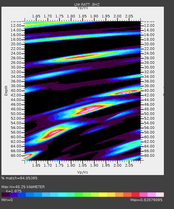
| Estimated Moho Depth: |
48.25 km |
| Estimated Crust Vp/Vs: |
1.88 |
| Assumed Crust Vp: |
6.597 km/s |
| Estimated Crust Vs: |
3.519 km/s |
| Estimated Crust Poisson's Ratio: |
0.30 |
|
| Radial Match: |
94.85395 % |
| Radial Bump: |
400 |
| Transverse Match: |
85.74245 % |
| Transverse Bump: |
400 |
| SOD ConfigId: |
13570011 |
| Insert Time: |
2019-05-01 12:51:16.938 +0000 |
| GWidth: |
2.5 |
| Max Bumps: |
400 |
| Tol: |
0.001 |
|

Signal To Noise
| Channel | StoN | STA | LTA |
| UW:RATT: :BHZ:20181013T11:18:14.714996Z | 57.244648 | 1.0441231E-5 | 1.8239663E-7 |
| UW:RATT: :BHN:20181013T11:18:14.714996Z | 25.304348 | 2.0794125E-6 | 8.217609E-8 |
| UW:RATT: :BHE:20181013T11:18:14.714996Z | 17.5971 | 3.6220279E-6 | 2.0583096E-7 |
| Arrivals |
| Ps | 6.8 SECOND |
| PpPs | 20 SECOND |
| PsPs/PpSs | 27 SECOND |


