You are here: Home > Network List > TA - USArray Transportable Network (new EarthScope stations) Stations List
> Station Z21A St. Cloud Mine, Winston, NM, USA > Earthquake Result Viewer
Z21A St. Cloud Mine, Winston, NM, USA - Earthquake Result Viewer
| Earthquake location: |
North Of Svalbard |
| Earthquake latitude/longitude: |
80.3/-1.9 |
| Earthquake time(UTC): |
2009/03/06 (065) 10:50:29 GMT |
| Earthquake Depth: |
9.0 km |
| Earthquake Magnitude: |
6.6 MB, 6.5 MS, 6.5 MW, 6.4 MW |
| Earthquake Catalog/Contributor: |
WHDF/NEIC |
|
| Network: |
TA USArray Transportable Network (new EarthScope stations) |
| Station: |
Z21A St. Cloud Mine, Winston, NM, USA |
| Lat/Lon: |
33.31 N/107.67 W |
| Elevation: |
1964 m |
|
| Distance: |
60.0 deg |
| Az: |
291.504 deg |
| Baz: |
10.834 deg |
| Ray Param: |
0.061825752 |
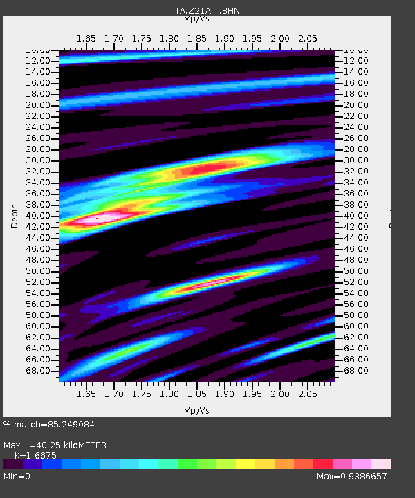
| Estimated Moho Depth: |
40.25 km |
| Estimated Crust Vp/Vs: |
1.67 |
| Assumed Crust Vp: |
6.502 km/s |
| Estimated Crust Vs: |
3.899 km/s |
| Estimated Crust Poisson's Ratio: |
0.22 |
|
| Radial Match: |
85.249084 % |
| Radial Bump: |
400 |
| Transverse Match: |
76.74408 % |
| Transverse Bump: |
400 |
| SOD ConfigId: |
2658 |
| Insert Time: |
2010-03-06 16:54:17.173 +0000 |
| GWidth: |
2.5 |
| Max Bumps: |
400 |
| Tol: |
0.001 |
|

Signal To Noise
| Channel | StoN | STA | LTA |
| TA:Z21A: :BHN:20090306T11:00:05.074001Z | 4.916528 | 2.4836538E-6 | 5.0516417E-7 |
| TA:Z21A: :BHE:20090306T11:00:05.074001Z | 3.6754375 | 1.2659897E-6 | 3.4444597E-7 |
| TA:Z21A: :BHZ:20090306T11:00:05.074001Z | 3.579247 | 5.7571606E-7 | 1.6084837E-7 |
| Arrivals |
| Ps | 4.4 SECOND |
| PpPs | 16 SECOND |
| PsPs/PpSs | 20 SECOND |


