You are here: Home > Network List > TA - USArray Transportable Network (new EarthScope stations) Stations List
> Station Z21A St. Cloud Mine, Winston, NM, USA > Earthquake Result Viewer
Z21A St. Cloud Mine, Winston, NM, USA - Earthquake Result Viewer
| Earthquake location: |
Baffin Bay |
| Earthquake latitude/longitude: |
75.4/-72.5 |
| Earthquake time(UTC): |
2009/07/07 (188) 19:11:46 GMT |
| Earthquake Depth: |
19 km |
| Earthquake Magnitude: |
5.9 MB, 5.7 MS, 6.1 MW, 6.0 MW |
| Earthquake Catalog/Contributor: |
WHDF/NEIC |
|
| Network: |
TA USArray Transportable Network (new EarthScope stations) |
| Station: |
Z21A St. Cloud Mine, Winston, NM, USA |
| Lat/Lon: |
33.31 N/107.67 W |
| Elevation: |
1964 m |
|
| Distance: |
45.4 deg |
| Az: |
222.746 deg |
| Baz: |
11.904 deg |
| Ray Param: |
0.07130697 |
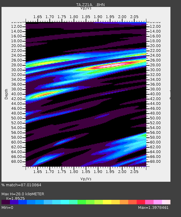
| Estimated Moho Depth: |
28.0 km |
| Estimated Crust Vp/Vs: |
1.95 |
| Assumed Crust Vp: |
6.502 km/s |
| Estimated Crust Vs: |
3.33 km/s |
| Estimated Crust Poisson's Ratio: |
0.32 |
|
| Radial Match: |
87.010864 % |
| Radial Bump: |
400 |
| Transverse Match: |
76.330826 % |
| Transverse Bump: |
400 |
| SOD ConfigId: |
2648 |
| Insert Time: |
2010-03-06 16:54:26.509 +0000 |
| GWidth: |
2.5 |
| Max Bumps: |
400 |
| Tol: |
0.001 |
|
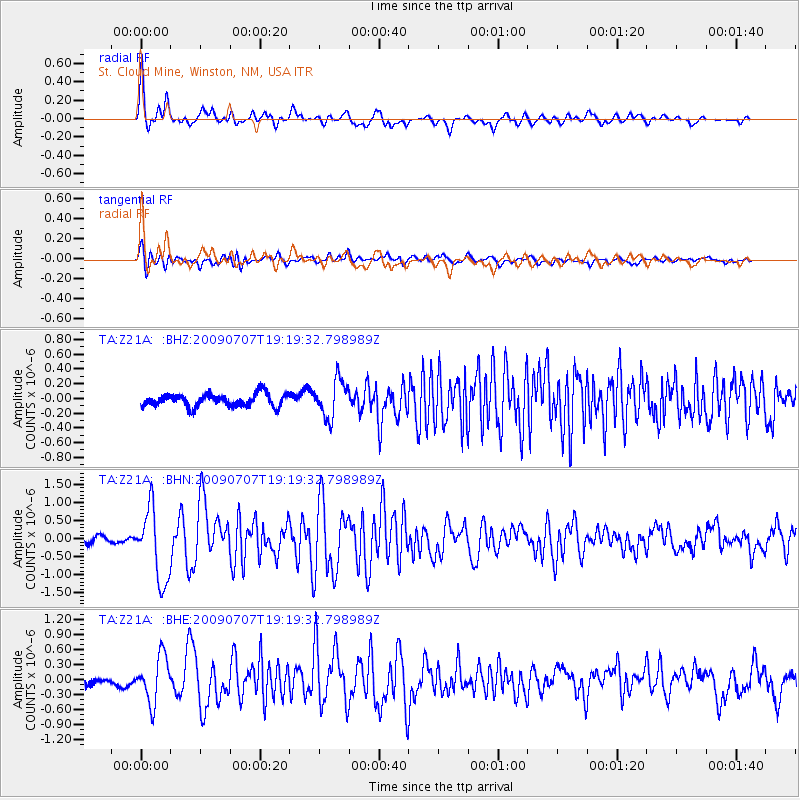
Signal To Noise
| Channel | StoN | STA | LTA |
| TA:Z21A: :BHN:20090707T19:19:32.798989Z | 10.794392 | 9.975356E-7 | 9.241239E-8 |
| TA:Z21A: :BHE:20090707T19:19:32.798989Z | 5.0074754 | 4.5528014E-7 | 9.0920096E-8 |
| TA:Z21A: :BHZ:20090707T19:19:32.798989Z | 2.9364586 | 2.5247073E-7 | 8.5977966E-8 |
| Arrivals |
| Ps | 4.4 SECOND |
| PpPs | 12 SECOND |
| PsPs/PpSs | 16 SECOND |


