You are here: Home > Network List > TA - USArray Transportable Network (new EarthScope stations) Stations List
> Station Z21A St. Cloud Mine, Winston, NM, USA > Earthquake Result Viewer
Z21A St. Cloud Mine, Winston, NM, USA - Earthquake Result Viewer
| Earthquake location: |
Kermadec Islands Region |
| Earthquake latitude/longitude: |
-31.5/-178.8 |
| Earthquake time(UTC): |
2009/05/16 (136) 00:53:52 GMT |
| Earthquake Depth: |
55 km |
| Earthquake Magnitude: |
6.1 MB, 6.5 MW, 6.3 MW |
| Earthquake Catalog/Contributor: |
WHDF/NEIC |
|
| Network: |
TA USArray Transportable Network (new EarthScope stations) |
| Station: |
Z21A St. Cloud Mine, Winston, NM, USA |
| Lat/Lon: |
33.31 N/107.67 W |
| Elevation: |
1964 m |
|
| Distance: |
93.0 deg |
| Az: |
52.511 deg |
| Baz: |
234.019 deg |
| Ray Param: |
0.041316178 |
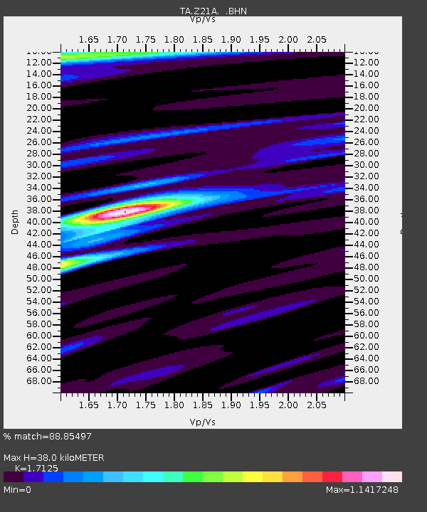
| Estimated Moho Depth: |
38.0 km |
| Estimated Crust Vp/Vs: |
1.71 |
| Assumed Crust Vp: |
6.502 km/s |
| Estimated Crust Vs: |
3.797 km/s |
| Estimated Crust Poisson's Ratio: |
0.24 |
|
| Radial Match: |
88.85497 % |
| Radial Bump: |
400 |
| Transverse Match: |
75.49241 % |
| Transverse Bump: |
400 |
| SOD ConfigId: |
2760 |
| Insert Time: |
2010-03-06 16:54:34.373 +0000 |
| GWidth: |
2.5 |
| Max Bumps: |
400 |
| Tol: |
0.001 |
|

Signal To Noise
| Channel | StoN | STA | LTA |
| TA:Z21A: :BHN:20090516T01:06:29.099009Z | 12.545861 | 1.0591766E-6 | 8.4424386E-8 |
| TA:Z21A: :BHE:20090516T01:06:29.099009Z | 3.226406 | 2.281859E-7 | 7.072448E-8 |
| TA:Z21A: :BHZ:20090516T01:06:29.099009Z | 4.158834 | 2.2015037E-7 | 5.2935597E-8 |
| Arrivals |
| Ps | 4.3 SECOND |
| PpPs | 16 SECOND |
| PsPs/PpSs | 20 SECOND |


