You are here: Home > Network List > TA - USArray Transportable Network (new EarthScope stations) Stations List
> Station Z21A St. Cloud Mine, Winston, NM, USA > Earthquake Result Viewer
Z21A St. Cloud Mine, Winston, NM, USA - Earthquake Result Viewer
| Earthquake location: |
Tonga Islands |
| Earthquake latitude/longitude: |
-20.8/-173.3 |
| Earthquake time(UTC): |
2008/06/26 (178) 21:19:15 GMT |
| Earthquake Depth: |
38 km |
| Earthquake Magnitude: |
6.0 MB, 5.8 MS, 6.2 MW, 6.1 MW |
| Earthquake Catalog/Contributor: |
WHDF/NEIC |
|
| Network: |
TA USArray Transportable Network (new EarthScope stations) |
| Station: |
Z21A St. Cloud Mine, Winston, NM, USA |
| Lat/Lon: |
33.31 N/107.67 W |
| Elevation: |
1964 m |
|
| Distance: |
82.5 deg |
| Az: |
50.317 deg |
| Baz: |
239.319 deg |
| Ray Param: |
0.046774827 |
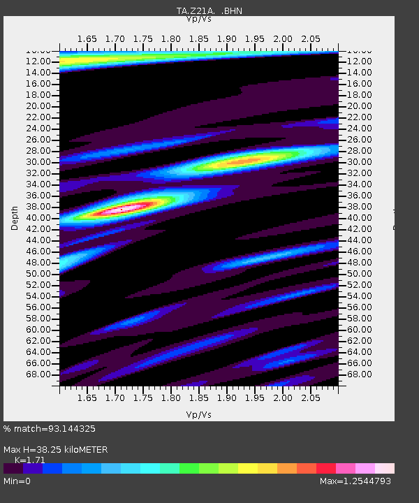
| Estimated Moho Depth: |
38.25 km |
| Estimated Crust Vp/Vs: |
1.71 |
| Assumed Crust Vp: |
6.502 km/s |
| Estimated Crust Vs: |
3.802 km/s |
| Estimated Crust Poisson's Ratio: |
0.24 |
|
| Radial Match: |
93.144325 % |
| Radial Bump: |
400 |
| Transverse Match: |
83.64618 % |
| Transverse Bump: |
400 |
| SOD ConfigId: |
2504 |
| Insert Time: |
2010-03-06 16:54:45.702 +0000 |
| GWidth: |
2.5 |
| Max Bumps: |
400 |
| Tol: |
0.001 |
|

Signal To Noise
| Channel | StoN | STA | LTA |
| TA:Z21A: :BHN:20080626T21:31:03.249006Z | 25.392117 | 1.9437862E-6 | 7.6550776E-8 |
| TA:Z21A: :BHE:20080626T21:31:03.249006Z | 3.4616084 | 3.3584385E-7 | 9.7019594E-8 |
| TA:Z21A: :BHZ:20080626T21:31:03.249006Z | 7.418068 | 4.823487E-7 | 6.502349E-8 |
| Arrivals |
| Ps | 4.3 SECOND |
| PpPs | 16 SECOND |
| PsPs/PpSs | 20 SECOND |


