You are here: Home > Network List > US - United States National Seismic Network Stations List
> Station HAWA Hanford, Washington, USA > Earthquake Result Viewer
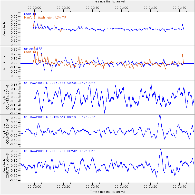
HAWA Hanford, Washington, USA - Earthquake Result Viewer
*The percent match for this event was below the threshold and hence no stack was calculated.
| Earthquake location: |
Off Coast Of Guerrero, Mexico |
| Earthquake latitude/longitude: |
14.9/-103.5 |
| Earthquake time(UTC): |
2016/07/23 (205) 08:52:02 GMT |
| Earthquake Depth: |
45 km |
| Earthquake Magnitude: |
5.5 MB |
| Earthquake Catalog/Contributor: |
NEIC PDE/NEIC COMCAT |
|
| Network: |
US United States National Seismic Network |
| Station: |
HAWA Hanford, Washington, USA |
| Lat/Lon: |
46.39 N/119.53 W |
| Elevation: |
364 m |
|
| Distance: |
34.2 deg |
| Az: |
340.145 deg |
| Baz: |
151.672 deg |
| Ray Param: |
$rayparam |
*The percent match for this event was below the threshold and hence was not used in the summary stack. |
|
| Radial Match: |
60.30072 % |
| Radial Bump: |
400 |
| Transverse Match: |
56.338806 % |
| Transverse Bump: |
397 |
| SOD ConfigId: |
1634031 |
| Insert Time: |
2016-08-17 08:13:54.459 +0000 |
| GWidth: |
2.5 |
| Max Bumps: |
400 |
| Tol: |
0.001 |
|
Signal To Noise
| Channel | StoN | STA | LTA |
| US:HAWA:00:BHZ:20160723T08:58:13.474994Z | 1.7887421 | 1.9558237E-7 | 1.0934073E-7 |
| US:HAWA:00:BH1:20160723T08:58:13.474994Z | 1.040049 | 7.492037E-8 | 7.203543E-8 |
| US:HAWA:00:BH2:20160723T08:58:13.474994Z | 0.9472037 | 6.5663365E-8 | 6.9323384E-8 |
| Arrivals |
| Ps | |
| PpPs | |
| PsPs/PpSs | |


