You are here: Home > Network List > TA - USArray Transportable Network (new EarthScope stations) Stations List
> Station Z21A St. Cloud Mine, Winston, NM, USA > Earthquake Result Viewer
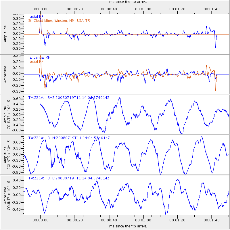
Z21A St. Cloud Mine, Winston, NM, USA - Earthquake Result Viewer
*The percent match for this event was below the threshold and hence no stack was calculated.
| Earthquake location: |
Santa Cruz Islands Region |
| Earthquake latitude/longitude: |
-11.1/164.6 |
| Earthquake time(UTC): |
2008/07/19 (201) 11:01:17 GMT |
| Earthquake Depth: |
10 km |
| Earthquake Magnitude: |
5.8 MB, 5.9 MS, 6.2 MW, 6.2 MW |
| Earthquake Catalog/Contributor: |
WHDF/NEIC |
|
| Network: |
TA USArray Transportable Network (new EarthScope stations) |
| Station: |
Z21A St. Cloud Mine, Winston, NM, USA |
| Lat/Lon: |
33.31 N/107.67 W |
| Elevation: |
1964 m |
|
| Distance: |
94.1 deg |
| Az: |
57.023 deg |
| Baz: |
259.539 deg |
| Ray Param: |
$rayparam |
*The percent match for this event was below the threshold and hence was not used in the summary stack. |
|
| Radial Match: |
73.273834 % |
| Radial Bump: |
340 |
| Transverse Match: |
70.432175 % |
| Transverse Bump: |
400 |
| SOD ConfigId: |
2504 |
| Insert Time: |
2010-03-06 16:55:07.033 +0000 |
| GWidth: |
2.5 |
| Max Bumps: |
400 |
| Tol: |
0.001 |
|
Signal To Noise
| Channel | StoN | STA | LTA |
| TA:Z21A: :BHN:20080719T11:14:04.574014Z | 1.0091655 | 5.1317375E-7 | 5.08513E-7 |
| TA:Z21A: :BHE:20080719T11:14:04.574014Z | 1.4758109 | 2.798287E-7 | 1.8961013E-7 |
| TA:Z21A: :BHZ:20080719T11:14:04.574014Z | 1.4429165 | 5.173816E-7 | 3.5856652E-7 |
| Arrivals |
| Ps | |
| PpPs | |
| PsPs/PpSs | |


