You are here: Home > Network List > CN - Canadian National Seismograph Network Stations List
> Station INK INUVIK, NT > Earthquake Result Viewer
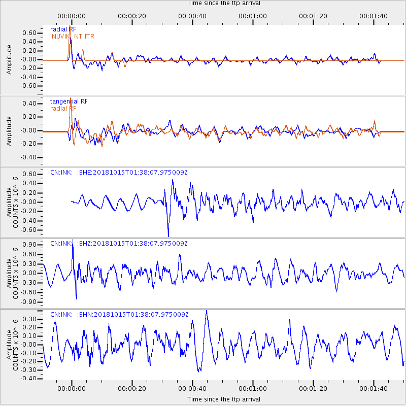
INK INUVIK, NT - Earthquake Result Viewer
*The percent match for this event was below the threshold and hence no stack was calculated.
| Earthquake location: |
Near East Coast Of Kamchatka |
| Earthquake latitude/longitude: |
54.1/159.5 |
| Earthquake time(UTC): |
2018/10/15 (288) 01:32:12 GMT |
| Earthquake Depth: |
124 km |
| Earthquake Magnitude: |
5.6 mb |
| Earthquake Catalog/Contributor: |
NEIC PDE/us |
|
| Network: |
CN Canadian National Seismograph Network |
| Station: |
INK INUVIK, NT |
| Lat/Lon: |
68.31 N/133.53 W |
| Elevation: |
44 m |
|
| Distance: |
33.3 deg |
| Az: |
38.524 deg |
| Baz: |
279.072 deg |
| Ray Param: |
$rayparam |
*The percent match for this event was below the threshold and hence was not used in the summary stack. |
|
| Radial Match: |
69.53379 % |
| Radial Bump: |
400 |
| Transverse Match: |
61.85801 % |
| Transverse Bump: |
400 |
| SOD ConfigId: |
13570011 |
| Insert Time: |
2019-05-01 12:59:43.278 +0000 |
| GWidth: |
2.5 |
| Max Bumps: |
400 |
| Tol: |
0.001 |
|
Signal To Noise
| Channel | StoN | STA | LTA |
| CN:INK: :BHZ:20181015T01:38:07.975009Z | 2.0060449 | 3.2847672E-7 | 1.6374345E-7 |
| CN:INK: :BHN:20181015T01:38:07.975009Z | 0.74998343 | 9.494513E-8 | 1.2659629E-7 |
| CN:INK: :BHE:20181015T01:38:07.975009Z | 2.9258256 | 2.723232E-7 | 9.3075684E-8 |
| Arrivals |
| Ps | |
| PpPs | |
| PsPs/PpSs | |


