You are here: Home > Network List > TA - USArray Transportable Network (new EarthScope stations) Stations List
> Station Z21A St. Cloud Mine, Winston, NM, USA > Earthquake Result Viewer
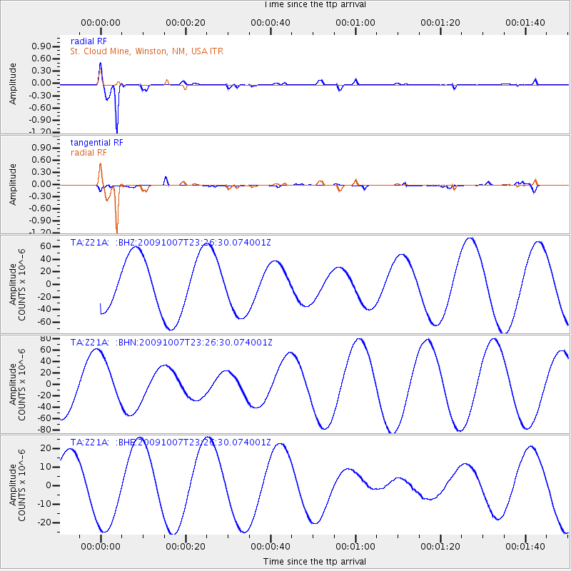
Z21A St. Cloud Mine, Winston, NM, USA - Earthquake Result Viewer
*The percent match for this event was below the threshold and hence no stack was calculated.
| Earthquake location: |
Vanuatu Islands |
| Earthquake latitude/longitude: |
-13.1/166.5 |
| Earthquake time(UTC): |
2009/10/07 (280) 23:13:48 GMT |
| Earthquake Depth: |
31 km |
| Earthquake Magnitude: |
6.4 MB, 7.2 MS, 7.4 MW, 7.4 MW |
| Earthquake Catalog/Contributor: |
WHDF/NEIC |
|
| Network: |
TA USArray Transportable Network (new EarthScope stations) |
| Station: |
Z21A St. Cloud Mine, Winston, NM, USA |
| Lat/Lon: |
33.31 N/107.67 W |
| Elevation: |
1964 m |
|
| Distance: |
93.7 deg |
| Az: |
56.814 deg |
| Baz: |
256.84 deg |
| Ray Param: |
$rayparam |
*The percent match for this event was below the threshold and hence was not used in the summary stack. |
|
| Radial Match: |
94.9489 % |
| Radial Bump: |
308 |
| Transverse Match: |
70.62183 % |
| Transverse Bump: |
400 |
| SOD ConfigId: |
2622 |
| Insert Time: |
2010-03-06 16:55:33.758 +0000 |
| GWidth: |
2.5 |
| Max Bumps: |
400 |
| Tol: |
0.001 |
|
Signal To Noise
| Channel | StoN | STA | LTA |
| TA:Z21A: :BHN:20091007T23:26:30.074001Z | 1.2295403 | 4.6266414E-5 | 3.7629034E-5 |
| TA:Z21A: :BHE:20091007T23:26:30.074001Z | 1.7309904 | 2.1600812E-5 | 1.2478874E-5 |
| TA:Z21A: :BHZ:20091007T23:26:30.074001Z | 0.8969143 | 4.0379382E-5 | 4.5020333E-5 |
| Arrivals |
| Ps | |
| PpPs | |
| PsPs/PpSs | |


