You are here: Home > Network List > TA - USArray Transportable Network (new EarthScope stations) Stations List
> Station Z21A St. Cloud Mine, Winston, NM, USA > Earthquake Result Viewer
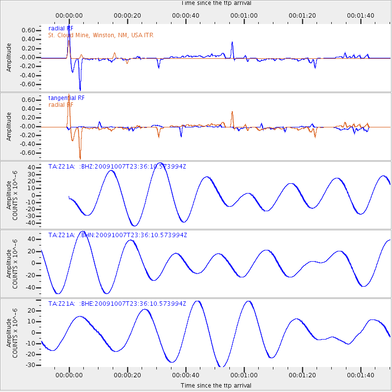
Z21A St. Cloud Mine, Winston, NM, USA - Earthquake Result Viewer
*The percent match for this event was below the threshold and hence no stack was calculated.
| Earthquake location: |
Santa Cruz Islands |
| Earthquake latitude/longitude: |
-12.6/166.0 |
| Earthquake time(UTC): |
2009/10/07 (280) 23:23:28 GMT |
| Earthquake Depth: |
36 km |
| Earthquake Magnitude: |
5.5 MB |
| Earthquake Catalog/Contributor: |
WHDF/NEIC |
|
| Network: |
TA USArray Transportable Network (new EarthScope stations) |
| Station: |
Z21A St. Cloud Mine, Winston, NM, USA |
| Lat/Lon: |
33.31 N/107.67 W |
| Elevation: |
1964 m |
|
| Distance: |
93.8 deg |
| Az: |
56.886 deg |
| Baz: |
257.57 deg |
| Ray Param: |
$rayparam |
*The percent match for this event was below the threshold and hence was not used in the summary stack. |
|
| Radial Match: |
79.01072 % |
| Radial Bump: |
400 |
| Transverse Match: |
72.24238 % |
| Transverse Bump: |
286 |
| SOD ConfigId: |
2622 |
| Insert Time: |
2010-03-06 16:55:35.513 +0000 |
| GWidth: |
2.5 |
| Max Bumps: |
400 |
| Tol: |
0.001 |
|
Signal To Noise
| Channel | StoN | STA | LTA |
| TA:Z21A: :BHN:20091007T23:36:10.573994Z | 1.3866501 | 3.4056957E-5 | 2.4560599E-5 |
| TA:Z21A: :BHE:20091007T23:36:10.573994Z | 1.9251764 | 1.3489502E-5 | 7.0068913E-6 |
| TA:Z21A: :BHZ:20091007T23:36:10.573994Z | 1.9310911 | 4.7077996E-5 | 2.4378962E-5 |
| Arrivals |
| Ps | |
| PpPs | |
| PsPs/PpSs | |


