You are here: Home > Network List > TA - USArray Transportable Network (new EarthScope stations) Stations List
> Station Z21A St. Cloud Mine, Winston, NM, USA > Earthquake Result Viewer
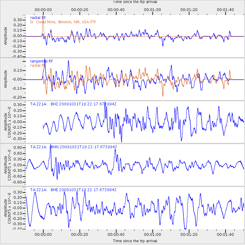
Z21A St. Cloud Mine, Winston, NM, USA - Earthquake Result Viewer
*The percent match for this event was below the threshold and hence no stack was calculated.
| Earthquake location: |
Santa Cruz Islands |
| Earthquake latitude/longitude: |
-11.4/166.4 |
| Earthquake time(UTC): |
2009/10/31 (304) 19:09:51 GMT |
| Earthquake Depth: |
134 km |
| Earthquake Magnitude: |
5.9 MB, 5.9 MW, 5.9 MW |
| Earthquake Catalog/Contributor: |
WHDF/NEIC |
|
| Network: |
TA USArray Transportable Network (new EarthScope stations) |
| Station: |
Z21A St. Cloud Mine, Winston, NM, USA |
| Lat/Lon: |
33.31 N/107.67 W |
| Elevation: |
1964 m |
|
| Distance: |
92.8 deg |
| Az: |
56.755 deg |
| Baz: |
258.335 deg |
| Ray Param: |
$rayparam |
*The percent match for this event was below the threshold and hence was not used in the summary stack. |
|
| Radial Match: |
50.86457 % |
| Radial Bump: |
400 |
| Transverse Match: |
43.834137 % |
| Transverse Bump: |
380 |
| SOD ConfigId: |
2622 |
| Insert Time: |
2010-03-06 16:55:43.083 +0000 |
| GWidth: |
2.5 |
| Max Bumps: |
400 |
| Tol: |
0.001 |
|
Signal To Noise
| Channel | StoN | STA | LTA |
| TA:Z21A: :BHN:20091031T19:22:17.673994Z | 1.8612291 | 3.5701484E-7 | 1.9181671E-7 |
| TA:Z21A: :BHE:20091031T19:22:17.673994Z | 0.5140372 | 1.11999114E-7 | 2.1788135E-7 |
| TA:Z21A: :BHZ:20091031T19:22:17.673994Z | 1.4232035 | 1.4159424E-7 | 9.94898E-8 |
| Arrivals |
| Ps | |
| PpPs | |
| PsPs/PpSs | |


