You are here: Home > Network List > TA - USArray Transportable Network (new EarthScope stations) Stations List
> Station I30M Mount Dempster, Yukon, CAN > Earthquake Result Viewer
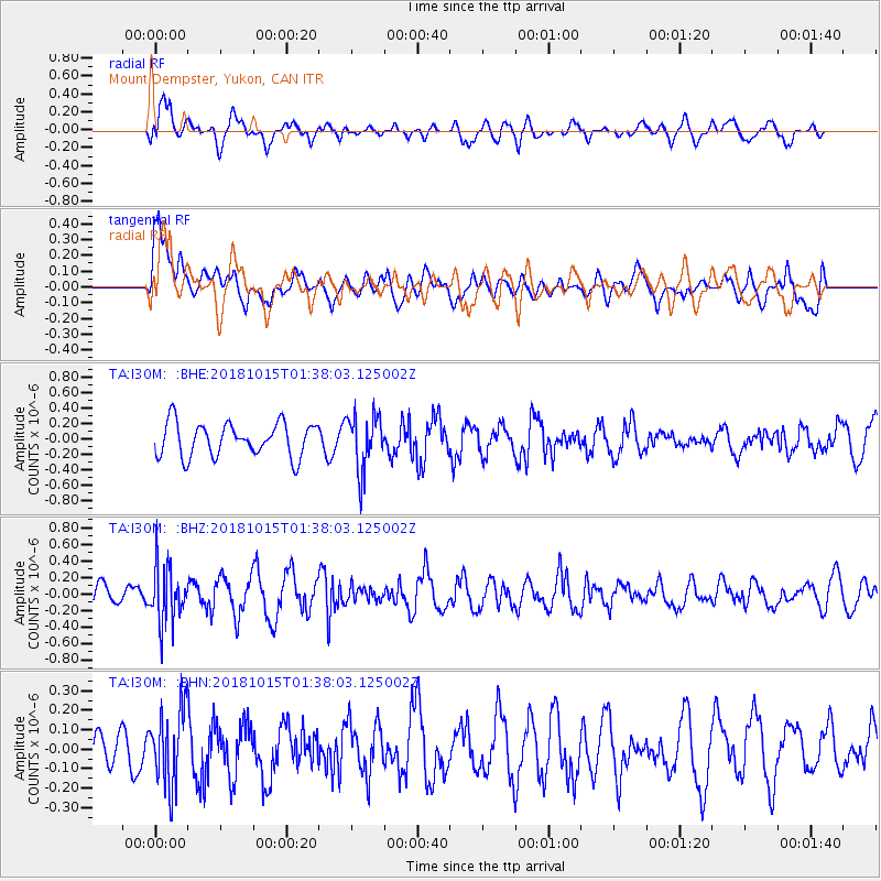
I30M Mount Dempster, Yukon, CAN - Earthquake Result Viewer
*The percent match for this event was below the threshold and hence no stack was calculated.
| Earthquake location: |
Near East Coast Of Kamchatka |
| Earthquake latitude/longitude: |
54.1/159.5 |
| Earthquake time(UTC): |
2018/10/15 (288) 01:32:12 GMT |
| Earthquake Depth: |
124 km |
| Earthquake Magnitude: |
5.6 mb |
| Earthquake Catalog/Contributor: |
NEIC PDE/us |
|
| Network: |
TA USArray Transportable Network (new EarthScope stations) |
| Station: |
I30M Mount Dempster, Yukon, CAN |
| Lat/Lon: |
65.22 N/136.38 W |
| Elevation: |
1399 m |
|
| Distance: |
32.8 deg |
| Az: |
44.484 deg |
| Baz: |
281.45 deg |
| Ray Param: |
$rayparam |
*The percent match for this event was below the threshold and hence was not used in the summary stack. |
|
| Radial Match: |
56.21783 % |
| Radial Bump: |
400 |
| Transverse Match: |
54.4419 % |
| Transverse Bump: |
400 |
| SOD ConfigId: |
13570011 |
| Insert Time: |
2019-05-01 13:04:58.838 +0000 |
| GWidth: |
2.5 |
| Max Bumps: |
400 |
| Tol: |
0.001 |
|
Signal To Noise
| Channel | StoN | STA | LTA |
| TA:I30M: :BHZ:20181015T01:38:03.125002Z | 2.6245747 | 3.474026E-7 | 1.3236529E-7 |
| TA:I30M: :BHN:20181015T01:38:03.125002Z | 1.5507157 | 1.9252138E-7 | 1.2415002E-7 |
| TA:I30M: :BHE:20181015T01:38:03.125002Z | 1.6454417 | 3.5530073E-7 | 2.159303E-7 |
| Arrivals |
| Ps | |
| PpPs | |
| PsPs/PpSs | |


