You are here: Home > Network List > TA - USArray Transportable Network (new EarthScope stations) Stations List
> Station Z21A St. Cloud Mine, Winston, NM, USA > Earthquake Result Viewer
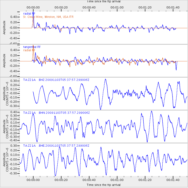
Z21A St. Cloud Mine, Winston, NM, USA - Earthquake Result Viewer
*The percent match for this event was below the threshold and hence no stack was calculated.
| Earthquake location: |
Ionian Sea |
| Earthquake latitude/longitude: |
37.5/20.5 |
| Earthquake time(UTC): |
2009/11/03 (307) 05:25:08 GMT |
| Earthquake Depth: |
10 km |
| Earthquake Magnitude: |
5.5 MB, 5.3 MS, 5.8 MW, 5.7 MW |
| Earthquake Catalog/Contributor: |
WHDF/NEIC |
|
| Network: |
TA USArray Transportable Network (new EarthScope stations) |
| Station: |
Z21A St. Cloud Mine, Winston, NM, USA |
| Lat/Lon: |
33.31 N/107.67 W |
| Elevation: |
1964 m |
|
| Distance: |
94.6 deg |
| Az: |
318.658 deg |
| Baz: |
38.853 deg |
| Ray Param: |
$rayparam |
*The percent match for this event was below the threshold and hence was not used in the summary stack. |
|
| Radial Match: |
67.397865 % |
| Radial Bump: |
400 |
| Transverse Match: |
56.3609 % |
| Transverse Bump: |
400 |
| SOD ConfigId: |
2622 |
| Insert Time: |
2010-03-06 16:55:45.822 +0000 |
| GWidth: |
2.5 |
| Max Bumps: |
400 |
| Tol: |
0.001 |
|
Signal To Noise
| Channel | StoN | STA | LTA |
| TA:Z21A: :BHN:20091103T05:37:57.299006Z | 1.7105426 | 2.7247725E-7 | 1.5929288E-7 |
| TA:Z21A: :BHE:20091103T05:37:57.299006Z | 1.1520568 | 1.0005213E-7 | 8.6846526E-8 |
| TA:Z21A: :BHZ:20091103T05:37:57.299006Z | 1.1628116 | 1.3006049E-7 | 1.1185E-7 |
| Arrivals |
| Ps | |
| PpPs | |
| PsPs/PpSs | |


