You are here: Home > Network List > TA - USArray Transportable Network (new EarthScope stations) Stations List
> Station Z21A St. Cloud Mine, Winston, NM, USA > Earthquake Result Viewer
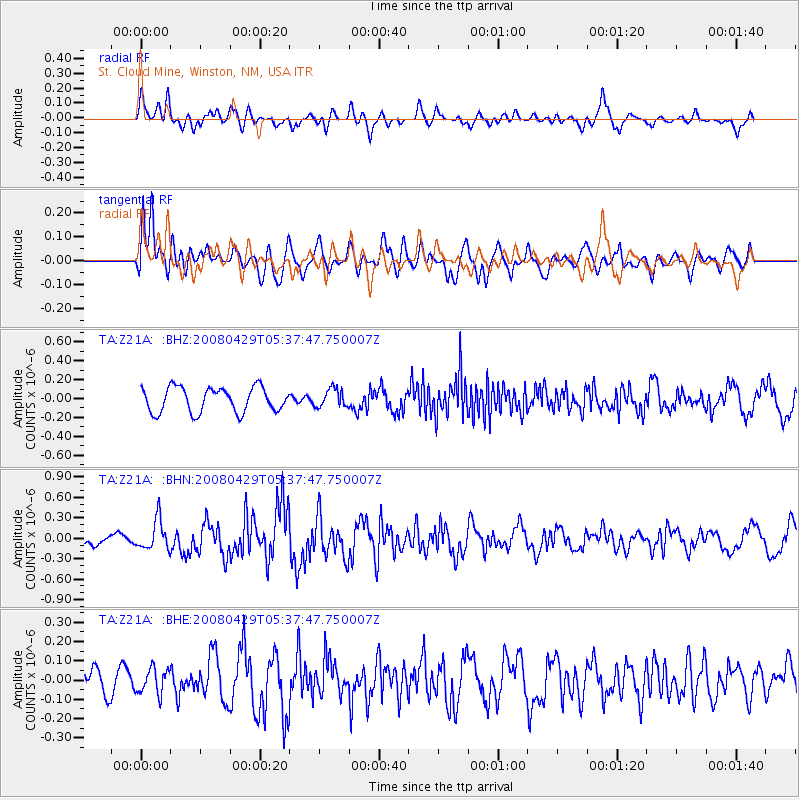
Z21A St. Cloud Mine, Winston, NM, USA - Earthquake Result Viewer
*The percent match for this event was below the threshold and hence no stack was calculated.
| Earthquake location: |
Hokkaido, Japan Region |
| Earthquake latitude/longitude: |
41.5/142.0 |
| Earthquake time(UTC): |
2008/04/29 (120) 05:26:04 GMT |
| Earthquake Depth: |
47 km |
| Earthquake Magnitude: |
5.5 MB, 5.2 MS, 5.8 MW, 5.8 MW |
| Earthquake Catalog/Contributor: |
WHDF/NEIC |
|
| Network: |
TA USArray Transportable Network (new EarthScope stations) |
| Station: |
Z21A St. Cloud Mine, Winston, NM, USA |
| Lat/Lon: |
33.31 N/107.67 W |
| Elevation: |
1964 m |
|
| Distance: |
81.8 deg |
| Az: |
52.51 deg |
| Baz: |
314.581 deg |
| Ray Param: |
$rayparam |
*The percent match for this event was below the threshold and hence was not used in the summary stack. |
|
| Radial Match: |
60.34763 % |
| Radial Bump: |
400 |
| Transverse Match: |
64.05418 % |
| Transverse Bump: |
400 |
| SOD ConfigId: |
2504 |
| Insert Time: |
2010-03-06 16:56:22.318 +0000 |
| GWidth: |
2.5 |
| Max Bumps: |
400 |
| Tol: |
0.001 |
|
Signal To Noise
| Channel | StoN | STA | LTA |
| TA:Z21A: :BHN:20080429T05:37:47.750007Z | 2.0857544 | 2.1796988E-7 | 1.04504096E-7 |
| TA:Z21A: :BHE:20080429T05:37:47.750007Z | 0.6744324 | 6.496836E-8 | 9.6330425E-8 |
| TA:Z21A: :BHZ:20080429T05:37:47.750007Z | 0.74956715 | 9.7602246E-8 | 1.3021148E-7 |
| Arrivals |
| Ps | |
| PpPs | |
| PsPs/PpSs | |


