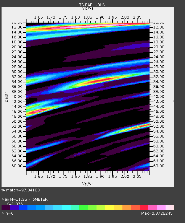
BAR Barrett Dam, California, USA - Earthquake Result Viewer
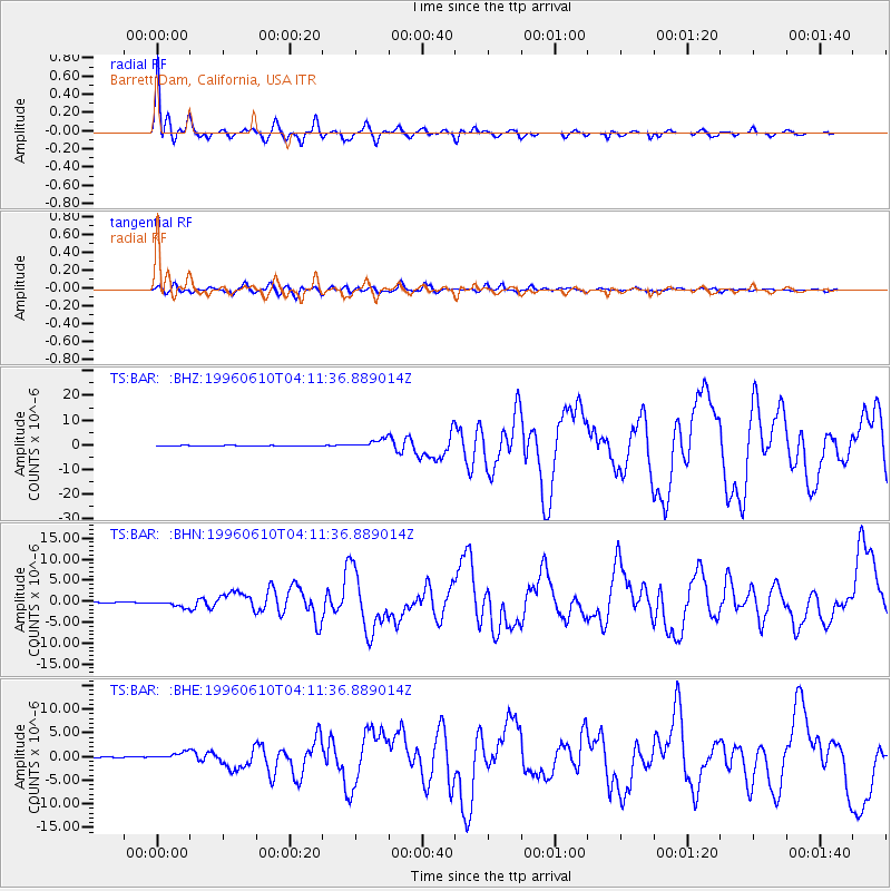
Earthquake location: Andreanof Islands, Aleutian Is.
Earthquake latitude/longitude: 51.6/-177.6
Earthquake time(UTC): 1996/06/10 (162) 04:03:35 GMT
Earthquake Depth: 33 km
Earthquake Magnitude: 6.6 MB, 7.6 MS, 7.9 UNKNOWN, 7.4 MS
Earthquake Catalog/Contributor: WHDF/NEIC
Network: TS TERRAscope (Southern California Seismic Network)
Station: BAR Barrett Dam, California, USA
Lat/Lon: 32.68 N/116.67 W
Elevation: 548 m
Distance: 47.5 deg
Az: 88.788 deg
Baz: 312.27 deg
Ray Param: 0.069873974
Estimated Moho Depth: 11.25 km
Estimated Crust Vp/Vs: 1.88
Assumed Crust Vp: 6.264 km/s
Estimated Crust Vs: 3.341 km/s
Estimated Crust Poisson's Ratio: 0.30
Radial Match: 97.34103 %
Radial Bump: 400
Transverse Match: 88.031425 %
Transverse Bump: 400
SOD ConfigId: 6273
Insert Time: 2010-02-26 13:58:57.317 +0000
GWidth: 2.5
Max Bumps: 400
Tol: 0.001

Signal To Noise

ChannelStoNSTALTA
TS:BAR: :BHN:19960610T04:11:36.889014Z9.3088988.262388E-78.875796E-8
TS:BAR: :BHE:19960610T04:11:36.889014Z8.7685927.819303E-78.917398E-8
TS:BAR: :BHZ:19960610T04:11:36.889014Z12.283221.7800091E-61.4491388E-7
Arrivals
Ps1.7 SECOND
PpPs4.9 SECOND
PsPs/PpSs6.5 SECOND