You are here: Home > Network List > TA - USArray Transportable Network (new EarthScope stations) Stations List
> Station Z21A St. Cloud Mine, Winston, NM, USA > Earthquake Result Viewer
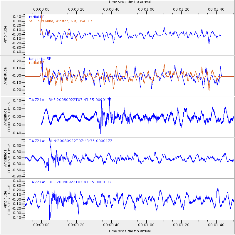
Z21A St. Cloud Mine, Winston, NM, USA - Earthquake Result Viewer
*The percent match for this event was below the threshold and hence no stack was calculated.
| Earthquake location: |
Hokkaido, Japan Region |
| Earthquake latitude/longitude: |
41.6/140.4 |
| Earthquake time(UTC): |
2008/09/22 (266) 07:31:59 GMT |
| Earthquake Depth: |
149 km |
| Earthquake Magnitude: |
5.7 MW, 5.3 MB, 5.6 MW |
| Earthquake Catalog/Contributor: |
WHDF/NEIC |
|
| Network: |
TA USArray Transportable Network (new EarthScope stations) |
| Station: |
Z21A St. Cloud Mine, Winston, NM, USA |
| Lat/Lon: |
33.31 N/107.67 W |
| Elevation: |
1964 m |
|
| Distance: |
82.7 deg |
| Az: |
51.579 deg |
| Baz: |
315.418 deg |
| Ray Param: |
$rayparam |
*The percent match for this event was below the threshold and hence was not used in the summary stack. |
|
| Radial Match: |
58.942314 % |
| Radial Bump: |
400 |
| Transverse Match: |
57.59293 % |
| Transverse Bump: |
400 |
| SOD ConfigId: |
2560 |
| Insert Time: |
2010-03-06 16:56:55.498 +0000 |
| GWidth: |
2.5 |
| Max Bumps: |
400 |
| Tol: |
0.001 |
|
Signal To Noise
| Channel | StoN | STA | LTA |
| TA:Z21A: :BHN:20080922T07:43:35.000017Z | 6.894652 | 3.6804212E-7 | 5.3380813E-8 |
| TA:Z21A: :BHE:20080922T07:43:35.000017Z | 2.064912 | 1.4149279E-7 | 6.852243E-8 |
| TA:Z21A: :BHZ:20080922T07:43:35.000017Z | 1.8483733 | 1.4543932E-7 | 7.8685034E-8 |
| Arrivals |
| Ps | |
| PpPs | |
| PsPs/PpSs | |


