You are here: Home > Network List > NN - Western Great Basin/Eastern Sierra Nevada Stations List
> Station EMB Emerald Bay, California w84 > Earthquake Result Viewer
EMB Emerald Bay, California w84 - Earthquake Result Viewer
| Earthquake location: |
Southeast Of Loyalty Islands |
| Earthquake latitude/longitude: |
-21.9/169.5 |
| Earthquake time(UTC): |
2018/10/16 (289) 00:28:12 GMT |
| Earthquake Depth: |
10 km |
| Earthquake Magnitude: |
6.3 Mww |
| Earthquake Catalog/Contributor: |
NEIC PDE/us |
|
| Network: |
NN Western Great Basin/Eastern Sierra Nevada |
| Station: |
EMB Emerald Bay, California w84 |
| Lat/Lon: |
38.97 N/120.10 W |
| Elevation: |
2134 m |
|
| Distance: |
89.4 deg |
| Az: |
47.261 deg |
| Baz: |
241.024 deg |
| Ray Param: |
0.041852448 |
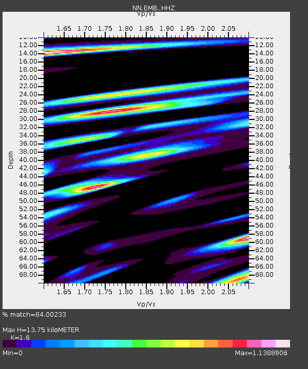
| Estimated Moho Depth: |
13.75 km |
| Estimated Crust Vp/Vs: |
1.60 |
| Assumed Crust Vp: |
6.597 km/s |
| Estimated Crust Vs: |
4.123 km/s |
| Estimated Crust Poisson's Ratio: |
0.18 |
|
| Radial Match: |
84.00233 % |
| Radial Bump: |
400 |
| Transverse Match: |
69.347336 % |
| Transverse Bump: |
400 |
| SOD ConfigId: |
13570011 |
| Insert Time: |
2019-05-01 13:18:01.769 +0000 |
| GWidth: |
2.5 |
| Max Bumps: |
400 |
| Tol: |
0.001 |
|

Signal To Noise
| Channel | StoN | STA | LTA |
| NN:EMB: :HHZ:20181016T00:40:38.06801Z | 2.9987648 | 4.1314624E-7 | 1.3777213E-7 |
| NN:EMB: :HHN:20181016T00:40:38.06801Z | 0.84455043 | 1.886754E-7 | 2.2340335E-7 |
| NN:EMB: :HHE:20181016T00:40:38.06801Z | 0.98000365 | 1.7488992E-7 | 1.7845845E-7 |
| Arrivals |
| Ps | 1.3 SECOND |
| PpPs | 5.3 SECOND |
| PsPs/PpSs | 6.6 SECOND |


