You are here: Home > Network List > TA - USArray Transportable Network (new EarthScope stations) Stations List
> Station F20K Avaraart Lake, AK, USA > Earthquake Result Viewer
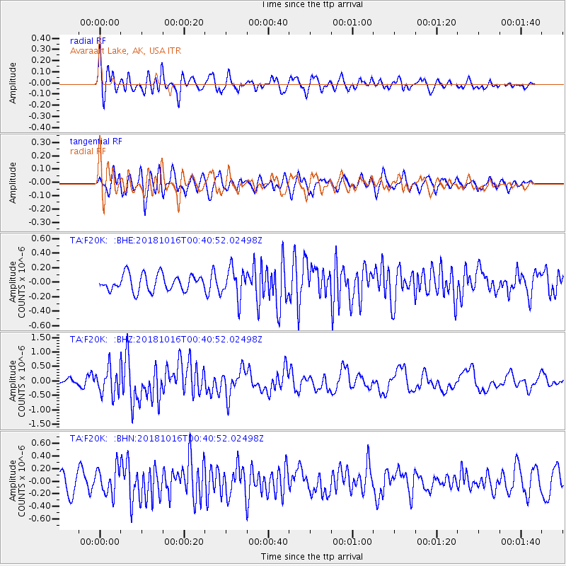
F20K Avaraart Lake, AK, USA - Earthquake Result Viewer
*The percent match for this event was below the threshold and hence no stack was calculated.
| Earthquake location: |
Southeast Of Loyalty Islands |
| Earthquake latitude/longitude: |
-21.9/169.5 |
| Earthquake time(UTC): |
2018/10/16 (289) 00:28:12 GMT |
| Earthquake Depth: |
10 km |
| Earthquake Magnitude: |
6.3 Mww |
| Earthquake Catalog/Contributor: |
NEIC PDE/us |
|
| Network: |
TA USArray Transportable Network (new EarthScope stations) |
| Station: |
F20K Avaraart Lake, AK, USA |
| Lat/Lon: |
67.05 N/155.73 W |
| Elevation: |
136 m |
|
| Distance: |
92.4 deg |
| Az: |
12.945 deg |
| Baz: |
212.029 deg |
| Ray Param: |
$rayparam |
*The percent match for this event was below the threshold and hence was not used in the summary stack. |
|
| Radial Match: |
74.87645 % |
| Radial Bump: |
400 |
| Transverse Match: |
64.35172 % |
| Transverse Bump: |
400 |
| SOD ConfigId: |
13570011 |
| Insert Time: |
2019-05-01 13:19:22.889 +0000 |
| GWidth: |
2.5 |
| Max Bumps: |
400 |
| Tol: |
0.001 |
|
Signal To Noise
| Channel | StoN | STA | LTA |
| TA:F20K: :BHZ:20181016T00:40:52.02498Z | 4.1377573 | 4.6266186E-7 | 1.11814636E-7 |
| TA:F20K: :BHN:20181016T00:40:52.02498Z | 1.487434 | 2.1764724E-7 | 1.4632396E-7 |
| TA:F20K: :BHE:20181016T00:40:52.02498Z | 1.8305603 | 2.0434716E-7 | 1.1163093E-7 |
| Arrivals |
| Ps | |
| PpPs | |
| PsPs/PpSs | |


