You are here: Home > Network List > TA - USArray Transportable Network (new EarthScope stations) Stations List
> Station F21K Alatna River, AK, USA > Earthquake Result Viewer
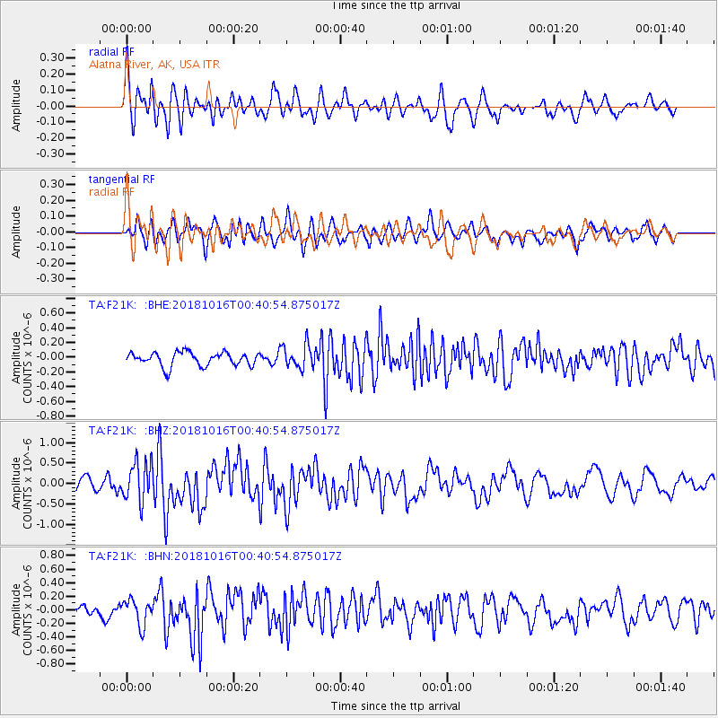
F21K Alatna River, AK, USA - Earthquake Result Viewer
*The percent match for this event was below the threshold and hence no stack was calculated.
| Earthquake location: |
Southeast Of Loyalty Islands |
| Earthquake latitude/longitude: |
-21.9/169.5 |
| Earthquake time(UTC): |
2018/10/16 (289) 00:28:12 GMT |
| Earthquake Depth: |
10 km |
| Earthquake Magnitude: |
6.3 Mww |
| Earthquake Catalog/Contributor: |
NEIC PDE/us |
|
| Network: |
TA USArray Transportable Network (new EarthScope stations) |
| Station: |
F21K Alatna River, AK, USA |
| Lat/Lon: |
67.22 N/153.48 W |
| Elevation: |
597 m |
|
| Distance: |
93.1 deg |
| Az: |
13.585 deg |
| Baz: |
214.063 deg |
| Ray Param: |
$rayparam |
*The percent match for this event was below the threshold and hence was not used in the summary stack. |
|
| Radial Match: |
74.752686 % |
| Radial Bump: |
400 |
| Transverse Match: |
61.8787 % |
| Transverse Bump: |
400 |
| SOD ConfigId: |
13570011 |
| Insert Time: |
2019-05-01 13:19:24.644 +0000 |
| GWidth: |
2.5 |
| Max Bumps: |
400 |
| Tol: |
0.001 |
|
Signal To Noise
| Channel | StoN | STA | LTA |
| TA:F21K: :BHZ:20181016T00:40:54.875017Z | 3.1947737 | 4.849618E-7 | 1.5179847E-7 |
| TA:F21K: :BHN:20181016T00:40:54.875017Z | 2.9416113 | 1.9121248E-7 | 6.500263E-8 |
| TA:F21K: :BHE:20181016T00:40:54.875017Z | 1.6932759 | 1.598753E-7 | 9.441775E-8 |
| Arrivals |
| Ps | |
| PpPs | |
| PsPs/PpSs | |


