You are here: Home > Network List > TS - TERRAscope (Southern California Seismic Network) Stations List
> Station BAR Barrett Dam, California, USA > Earthquake Result Viewer
BAR Barrett Dam, California, USA - Earthquake Result Viewer
| Earthquake location: |
Vanuatu Islands |
| Earthquake latitude/longitude: |
-13.5/167.1 |
| Earthquake time(UTC): |
1996/06/10 (162) 01:04:46 GMT |
| Earthquake Depth: |
200 km |
| Earthquake Magnitude: |
5.8 MB, 5.9 MS, 6.7 UNKNOWN, 6.0 MS |
| Earthquake Catalog/Contributor: |
WHDF/NEIC |
|
| Network: |
TS TERRAscope (Southern California Seismic Network) |
| Station: |
BAR Barrett Dam, California, USA |
| Lat/Lon: |
32.68 N/116.67 W |
| Elevation: |
548 m |
|
| Distance: |
85.9 deg |
| Az: |
55.193 deg |
| Baz: |
251.283 deg |
| Ray Param: |
0.04395788 |
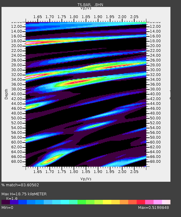
| Estimated Moho Depth: |
18.75 km |
| Estimated Crust Vp/Vs: |
1.60 |
| Assumed Crust Vp: |
6.264 km/s |
| Estimated Crust Vs: |
3.915 km/s |
| Estimated Crust Poisson's Ratio: |
0.18 |
|
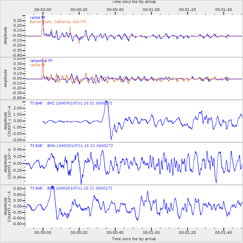
| Radial Match: |
83.60582 % |
| Radial Bump: |
400 |
| Transverse Match: |
72.66587 % |
| Transverse Bump: |
400 |
| SOD ConfigId: |
6273 |
| Insert Time: |
2010-02-26 13:58:59.034 +0000 |
| GWidth: |
2.5 |
| Max Bumps: |
400 |
| Tol: |
0.001 |
|
Signal To Noise
| Channel | StoN | STA | LTA |
| TS:BAR: :BHN:19960610T01:16:32.990027Z | 2.0127223 | 1.366785E-7 | 6.790728E-8 |
| TS:BAR: :BHE:19960610T01:16:32.990027Z | 5.486404 | 4.0370446E-7 | 7.358271E-8 |
| TS:BAR: :BHZ:19960610T01:16:32.990027Z | 10.484025 | 1.0690667E-6 | 1.0197101E-7 |
| Arrivals |
| Ps | 1.8 SECOND |
| PpPs | 7.6 SECOND |
| PsPs/PpSs | 9.4 SECOND |


