You are here: Home > Network List > TA - USArray Transportable Network (new EarthScope stations) Stations List
> Station O17K Koliganek, Bristol Bay, AK, USA > Earthquake Result Viewer
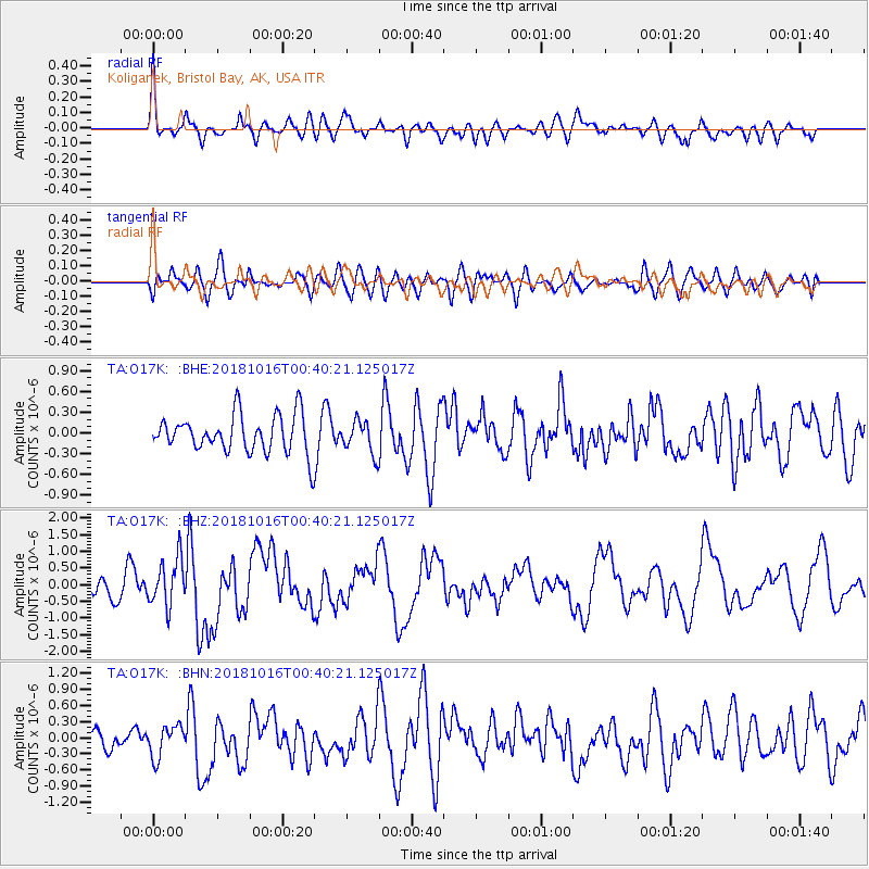
O17K Koliganek, Bristol Bay, AK, USA - Earthquake Result Viewer
*The percent match for this event was below the threshold and hence no stack was calculated.
| Earthquake location: |
Southeast Of Loyalty Islands |
| Earthquake latitude/longitude: |
-21.9/169.5 |
| Earthquake time(UTC): |
2018/10/16 (289) 00:28:12 GMT |
| Earthquake Depth: |
10 km |
| Earthquake Magnitude: |
6.3 Mww |
| Earthquake Catalog/Contributor: |
NEIC PDE/us |
|
| Network: |
TA USArray Transportable Network (new EarthScope stations) |
| Station: |
O17K Koliganek, Bristol Bay, AK, USA |
| Lat/Lon: |
59.77 N/157.09 W |
| Elevation: |
156 m |
|
| Distance: |
85.9 deg |
| Az: |
16.227 deg |
| Baz: |
210.852 deg |
| Ray Param: |
$rayparam |
*The percent match for this event was below the threshold and hence was not used in the summary stack. |
|
| Radial Match: |
70.62377 % |
| Radial Bump: |
400 |
| Transverse Match: |
60.54844 % |
| Transverse Bump: |
400 |
| SOD ConfigId: |
13570011 |
| Insert Time: |
2019-05-01 13:20:19.080 +0000 |
| GWidth: |
2.5 |
| Max Bumps: |
400 |
| Tol: |
0.001 |
|
Signal To Noise
| Channel | StoN | STA | LTA |
| TA:O17K: :BHZ:20181016T00:40:21.125017Z | 2.0516682 | 7.081129E-7 | 3.451401E-7 |
| TA:O17K: :BHN:20181016T00:40:21.125017Z | 1.2610368 | 2.9952784E-7 | 2.3752506E-7 |
| TA:O17K: :BHE:20181016T00:40:21.125017Z | 0.8617249 | 2.3219663E-7 | 2.6945563E-7 |
| Arrivals |
| Ps | |
| PpPs | |
| PsPs/PpSs | |


