You are here: Home > Network List > TA - USArray Transportable Network (new EarthScope stations) Stations List
> Station 426A McDonald Observatory, Fort Davis, TX, USA > Earthquake Result Viewer
426A McDonald Observatory, Fort Davis, TX, USA - Earthquake Result Viewer
| Earthquake location: |
Southeast Of Honshu, Japan |
| Earthquake latitude/longitude: |
32.8/140.4 |
| Earthquake time(UTC): |
2009/08/12 (224) 22:48:51 GMT |
| Earthquake Depth: |
53 km |
| Earthquake Magnitude: |
6.2 MB, 6.6 MW, 6.6 MW |
| Earthquake Catalog/Contributor: |
WHDF/NEIC |
|
| Network: |
TA USArray Transportable Network (new EarthScope stations) |
| Station: |
426A McDonald Observatory, Fort Davis, TX, USA |
| Lat/Lon: |
30.67 N/104.03 W |
| Elevation: |
1943 m |
|
| Distance: |
92.3 deg |
| Az: |
51.06 deg |
| Baz: |
310.526 deg |
| Ray Param: |
0.04146737 |
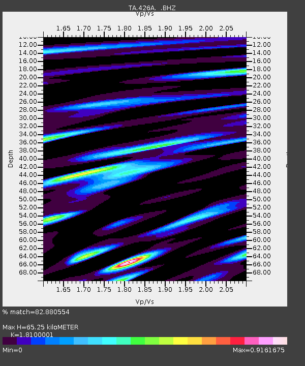
| Estimated Moho Depth: |
65.25 km |
| Estimated Crust Vp/Vs: |
1.81 |
| Assumed Crust Vp: |
6.361 km/s |
| Estimated Crust Vs: |
3.514 km/s |
| Estimated Crust Poisson's Ratio: |
0.28 |
|
| Radial Match: |
82.880554 % |
| Radial Bump: |
400 |
| Transverse Match: |
75.83659 % |
| Transverse Bump: |
400 |
| SOD ConfigId: |
2622 |
| Insert Time: |
2010-03-06 16:57:30.630 +0000 |
| GWidth: |
2.5 |
| Max Bumps: |
400 |
| Tol: |
0.001 |
|

Signal To Noise
| Channel | StoN | STA | LTA |
| TA:426A: :BHZ:20090812T23:01:24.399004Z | 20.715357 | 1.3471335E-6 | 6.5030676E-8 |
| TA:426A: :BHN:20090812T23:01:24.399004Z | 8.319145 | 4.406619E-7 | 5.2969607E-8 |
| TA:426A: :BHE:20090812T23:01:24.399004Z | 7.435082 | 3.1481068E-7 | 4.2341252E-8 |
| Arrivals |
| Ps | 8.5 SECOND |
| PpPs | 28 SECOND |
| PsPs/PpSs | 37 SECOND |


