You are here: Home > Network List > UO - University of Oregon Regional Network Stations List
> Station DFAZ Toketee, OR, USA > Earthquake Result Viewer
DFAZ Toketee, OR, USA - Earthquake Result Viewer
| Earthquake location: |
Southeast Of Loyalty Islands |
| Earthquake latitude/longitude: |
-21.9/169.5 |
| Earthquake time(UTC): |
2018/10/16 (289) 00:28:12 GMT |
| Earthquake Depth: |
10 km |
| Earthquake Magnitude: |
6.3 Mww |
| Earthquake Catalog/Contributor: |
NEIC PDE/us |
|
| Network: |
UO University of Oregon Regional Network |
| Station: |
DFAZ Toketee, OR, USA |
| Lat/Lon: |
43.24 N/122.11 W |
| Elevation: |
1948 m |
|
| Distance: |
90.2 deg |
| Az: |
42.807 deg |
| Baz: |
239.696 deg |
| Ray Param: |
0.041688588 |
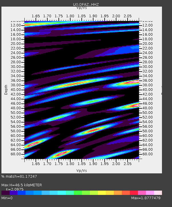
| Estimated Moho Depth: |
46.5 km |
| Estimated Crust Vp/Vs: |
2.10 |
| Assumed Crust Vp: |
6.522 km/s |
| Estimated Crust Vs: |
3.109 km/s |
| Estimated Crust Poisson's Ratio: |
0.35 |
|
| Radial Match: |
81.17247 % |
| Radial Bump: |
400 |
| Transverse Match: |
69.065384 % |
| Transverse Bump: |
400 |
| SOD ConfigId: |
13570011 |
| Insert Time: |
2019-05-01 13:20:46.699 +0000 |
| GWidth: |
2.5 |
| Max Bumps: |
400 |
| Tol: |
0.001 |
|

Signal To Noise
| Channel | StoN | STA | LTA |
| UO:DFAZ: :HHZ:20181016T00:40:41.727983Z | 3.6072528 | 6.5995994E-7 | 1.829536E-7 |
| UO:DFAZ: :HHN:20181016T00:40:41.727983Z | 0.92291224 | 2.4037075E-7 | 2.6044813E-7 |
| UO:DFAZ: :HHE:20181016T00:40:41.727983Z | 1.0380971 | 2.8110847E-7 | 2.7079207E-7 |
| Arrivals |
| Ps | 8.0 SECOND |
| PpPs | 22 SECOND |
| PsPs/PpSs | 30 SECOND |


