You are here: Home > Network List > AV - Alaska Volcano Observatory Stations List
> Station PLBL Mt. Peulik Volcano, Alaska > Earthquake Result Viewer
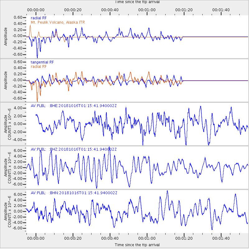
PLBL Mt. Peulik Volcano, Alaska - Earthquake Result Viewer
*The percent match for this event was below the threshold and hence no stack was calculated.
| Earthquake location: |
Southeast Of Loyalty Islands |
| Earthquake latitude/longitude: |
-21.7/169.4 |
| Earthquake time(UTC): |
2018/10/16 (289) 01:03:46 GMT |
| Earthquake Depth: |
10 km |
| Earthquake Magnitude: |
6.8 Mi |
| Earthquake Catalog/Contributor: |
NEIC PDE/at |
|
| Network: |
AV Alaska Volcano Observatory |
| Station: |
PLBL Mt. Peulik Volcano, Alaska |
| Lat/Lon: |
57.70 N/156.82 W |
| Elevation: |
461 m |
|
| Distance: |
84.0 deg |
| Az: |
17.447 deg |
| Baz: |
211.283 deg |
| Ray Param: |
$rayparam |
*The percent match for this event was below the threshold and hence was not used in the summary stack. |
|
| Radial Match: |
79.195625 % |
| Radial Bump: |
400 |
| Transverse Match: |
69.335236 % |
| Transverse Bump: |
400 |
| SOD ConfigId: |
13570011 |
| Insert Time: |
2019-05-01 13:22:53.645 +0000 |
| GWidth: |
2.5 |
| Max Bumps: |
400 |
| Tol: |
0.001 |
|
Signal To Noise
| Channel | StoN | STA | LTA |
| AV:PLBL: :BHZ:20181016T01:15:41.940002Z | 3.3072968 | 3.554534E-6 | 1.074755E-6 |
| AV:PLBL: :BHN:20181016T01:15:41.940002Z | 1.8450788 | 1.5333605E-6 | 8.310542E-7 |
| AV:PLBL: :BHE:20181016T01:15:41.940002Z | 1.1128886 | 1.7080839E-6 | 1.5348202E-6 |
| Arrivals |
| Ps | |
| PpPs | |
| PsPs/PpSs | |


