You are here: Home > Network List > TA - USArray Transportable Network (new EarthScope stations) Stations List
> Station D23K Nanushuk River, AK USA > Earthquake Result Viewer
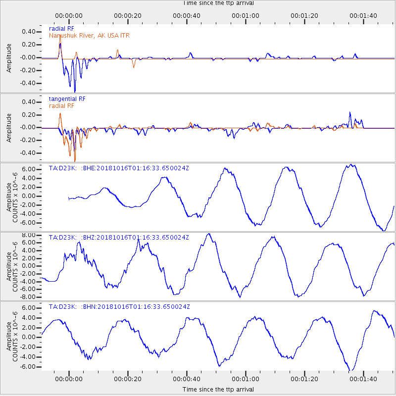
D23K Nanushuk River, AK USA - Earthquake Result Viewer
*The percent match for this event was below the threshold and hence no stack was calculated.
| Earthquake location: |
Southeast Of Loyalty Islands |
| Earthquake latitude/longitude: |
-21.7/169.4 |
| Earthquake time(UTC): |
2018/10/16 (289) 01:03:46 GMT |
| Earthquake Depth: |
10 km |
| Earthquake Magnitude: |
6.8 Mi |
| Earthquake Catalog/Contributor: |
NEIC PDE/at |
|
| Network: |
TA USArray Transportable Network (new EarthScope stations) |
| Station: |
D23K Nanushuk River, AK USA |
| Lat/Lon: |
68.97 N/150.68 W |
| Elevation: |
406 m |
|
| Distance: |
94.9 deg |
| Az: |
13.433 deg |
| Baz: |
216.751 deg |
| Ray Param: |
$rayparam |
*The percent match for this event was below the threshold and hence was not used in the summary stack. |
|
| Radial Match: |
98.66072 % |
| Radial Bump: |
229 |
| Transverse Match: |
76.87333 % |
| Transverse Bump: |
400 |
| SOD ConfigId: |
13570011 |
| Insert Time: |
2019-05-01 13:25:48.421 +0000 |
| GWidth: |
2.5 |
| Max Bumps: |
400 |
| Tol: |
0.001 |
|
Signal To Noise
| Channel | StoN | STA | LTA |
| TA:D23K: :BHZ:20181016T01:16:33.650024Z | 1.5873543 | 4.122166E-6 | 2.5968782E-6 |
| TA:D23K: :BHN:20181016T01:16:33.650024Z | 0.5824019 | 1.7394636E-6 | 2.9867067E-6 |
| TA:D23K: :BHE:20181016T01:16:33.650024Z | 2.461697 | 3.3348715E-6 | 1.3547043E-6 |
| Arrivals |
| Ps | |
| PpPs | |
| PsPs/PpSs | |


