You are here: Home > Network List > TA - USArray Transportable Network (new EarthScope stations) Stations List
> Station I23K Minto, Yukon-Koyukuk, AK, USA > Earthquake Result Viewer
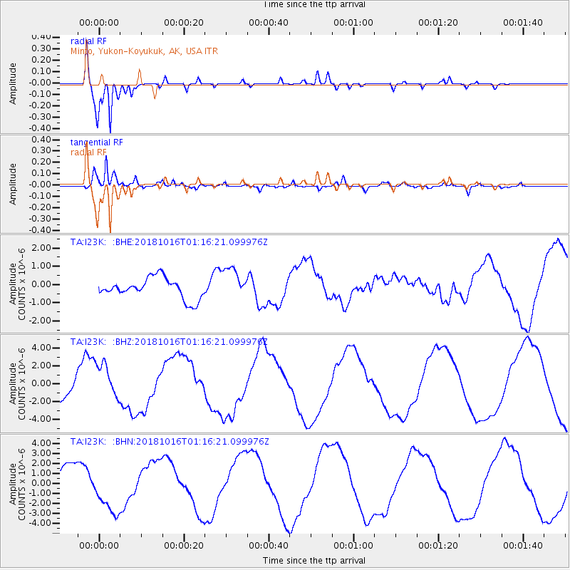
I23K Minto, Yukon-Koyukuk, AK, USA - Earthquake Result Viewer
*The percent match for this event was below the threshold and hence no stack was calculated.
| Earthquake location: |
Southeast Of Loyalty Islands |
| Earthquake latitude/longitude: |
-21.7/169.4 |
| Earthquake time(UTC): |
2018/10/16 (289) 01:03:46 GMT |
| Earthquake Depth: |
10 km |
| Earthquake Magnitude: |
6.8 Mi |
| Earthquake Catalog/Contributor: |
NEIC PDE/at |
|
| Network: |
TA USArray Transportable Network (new EarthScope stations) |
| Station: |
I23K Minto, Yukon-Koyukuk, AK, USA |
| Lat/Lon: |
65.15 N/149.36 W |
| Elevation: |
149 m |
|
| Distance: |
92.2 deg |
| Az: |
16.172 deg |
| Baz: |
217.798 deg |
| Ray Param: |
$rayparam |
*The percent match for this event was below the threshold and hence was not used in the summary stack. |
|
| Radial Match: |
95.46528 % |
| Radial Bump: |
287 |
| Transverse Match: |
70.667694 % |
| Transverse Bump: |
400 |
| SOD ConfigId: |
13570011 |
| Insert Time: |
2019-05-01 13:26:00.083 +0000 |
| GWidth: |
2.5 |
| Max Bumps: |
400 |
| Tol: |
0.001 |
|
Signal To Noise
| Channel | StoN | STA | LTA |
| TA:I23K: :BHZ:20181016T01:16:21.099976Z | 1.1407769 | 1.9674474E-6 | 1.7246558E-6 |
| TA:I23K: :BHN:20181016T01:16:21.099976Z | 1.6727427 | 2.6094679E-6 | 1.5599936E-6 |
| TA:I23K: :BHE:20181016T01:16:21.099976Z | 1.0409701 | 6.27648E-7 | 6.0294525E-7 |
| Arrivals |
| Ps | |
| PpPs | |
| PsPs/PpSs | |


