You are here: Home > Network List > TA - USArray Transportable Network (new EarthScope stations) Stations List
> Station R32K Eaglecrest, AK, USA > Earthquake Result Viewer
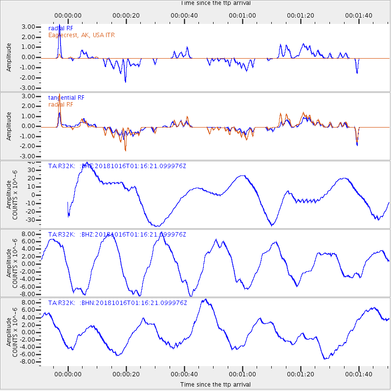
R32K Eaglecrest, AK, USA - Earthquake Result Viewer
*The percent match for this event was below the threshold and hence no stack was calculated.
| Earthquake location: |
Southeast Of Loyalty Islands |
| Earthquake latitude/longitude: |
-21.7/169.4 |
| Earthquake time(UTC): |
2018/10/16 (289) 01:03:46 GMT |
| Earthquake Depth: |
10 km |
| Earthquake Magnitude: |
6.8 Mi |
| Earthquake Catalog/Contributor: |
NEIC PDE/at |
|
| Network: |
TA USArray Transportable Network (new EarthScope stations) |
| Station: |
R32K Eaglecrest, AK, USA |
| Lat/Lon: |
58.27 N/134.52 W |
| Elevation: |
386 m |
|
| Distance: |
92.2 deg |
| Az: |
26.012 deg |
| Baz: |
230.516 deg |
| Ray Param: |
$rayparam |
*The percent match for this event was below the threshold and hence was not used in the summary stack. |
|
| Radial Match: |
40.492233 % |
| Radial Bump: |
400 |
| Transverse Match: |
32.027073 % |
| Transverse Bump: |
400 |
| SOD ConfigId: |
13570011 |
| Insert Time: |
2019-05-01 13:26:22.442 +0000 |
| GWidth: |
2.5 |
| Max Bumps: |
400 |
| Tol: |
0.001 |
|
Signal To Noise
| Channel | StoN | STA | LTA |
| TA:R32K: :BHZ:20181016T01:16:21.099976Z | 1.4009277 | 5.9303984E-6 | 4.2331935E-6 |
| TA:R32K: :BHN:20181016T01:16:21.099976Z | 1.0501555 | 5.7972184E-6 | 5.5203423E-6 |
| TA:R32K: :BHE:20181016T01:16:21.099976Z | 2.3476455 | 3.754731E-5 | 1.5993603E-5 |
| Arrivals |
| Ps | |
| PpPs | |
| PsPs/PpSs | |


