You are here: Home > Network List > AZ - ANZA Regional Network Stations List
> Station SMER AZ.SMER > Earthquake Result Viewer
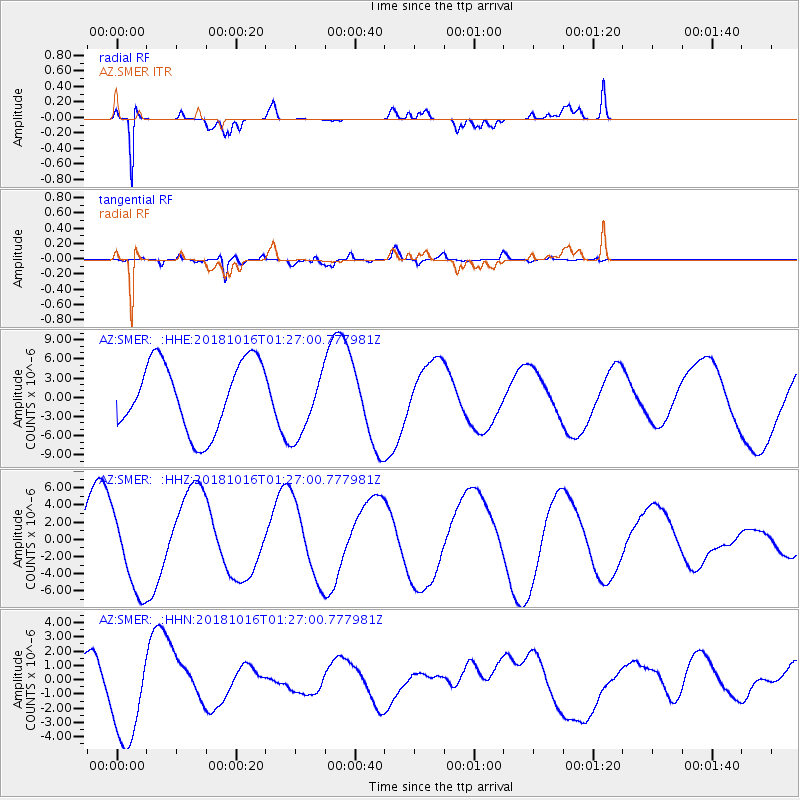
SMER AZ.SMER - Earthquake Result Viewer
*The percent match for this event was below the threshold and hence no stack was calculated.
| Earthquake location: |
Southeast Of Loyalty Islands |
| Earthquake latitude/longitude: |
-21.8/169.4 |
| Earthquake time(UTC): |
2018/10/16 (289) 01:14:37 GMT |
| Earthquake Depth: |
10 km |
| Earthquake Magnitude: |
5.8 Mww |
| Earthquake Catalog/Contributor: |
NEIC PDE/us |
|
| Network: |
AZ ANZA Regional Network |
| Station: |
SMER AZ.SMER |
| Lat/Lon: |
33.46 N/117.17 W |
| Elevation: |
355 m |
|
| Distance: |
88.9 deg |
| Az: |
53.276 deg |
| Baz: |
242.989 deg |
| Ray Param: |
$rayparam |
*The percent match for this event was below the threshold and hence was not used in the summary stack. |
|
| Radial Match: |
89.318344 % |
| Radial Bump: |
215 |
| Transverse Match: |
66.491684 % |
| Transverse Bump: |
400 |
| SOD ConfigId: |
13570011 |
| Insert Time: |
2019-05-01 13:28:35.462 +0000 |
| GWidth: |
2.5 |
| Max Bumps: |
400 |
| Tol: |
0.001 |
|
Signal To Noise
| Channel | StoN | STA | LTA |
| AZ:SMER: :HHZ:20181016T01:27:00.777981Z | 1.0330015 | 4.4943613E-6 | 4.350779E-6 |
| AZ:SMER: :HHN:20181016T01:27:00.777981Z | 1.9909534 | 3.6823071E-6 | 1.8495194E-6 |
| AZ:SMER: :HHE:20181016T01:27:00.777981Z | 0.98240966 | 5.3109156E-6 | 5.4060088E-6 |
| Arrivals |
| Ps | |
| PpPs | |
| PsPs/PpSs | |


