You are here: Home > Network List > CI - Caltech Regional Seismic Network Stations List
> Station FUR Furnace Creek, CA, USA > Earthquake Result Viewer
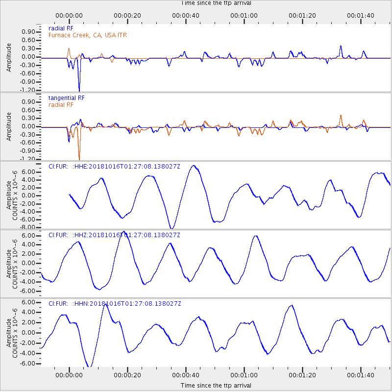
FUR Furnace Creek, CA, USA - Earthquake Result Viewer
*The percent match for this event was below the threshold and hence no stack was calculated.
| Earthquake location: |
Southeast Of Loyalty Islands |
| Earthquake latitude/longitude: |
-21.8/169.4 |
| Earthquake time(UTC): |
2018/10/16 (289) 01:14:37 GMT |
| Earthquake Depth: |
10 km |
| Earthquake Magnitude: |
5.8 Mww |
| Earthquake Catalog/Contributor: |
NEIC PDE/us |
|
| Network: |
CI Caltech Regional Seismic Network |
| Station: |
FUR Furnace Creek, CA, USA |
| Lat/Lon: |
36.47 N/116.86 W |
| Elevation: |
-37.0 m |
|
| Distance: |
90.5 deg |
| Az: |
50.714 deg |
| Baz: |
243.153 deg |
| Ray Param: |
$rayparam |
*The percent match for this event was below the threshold and hence was not used in the summary stack. |
|
| Radial Match: |
85.28157 % |
| Radial Bump: |
400 |
| Transverse Match: |
75.7416 % |
| Transverse Bump: |
400 |
| SOD ConfigId: |
13570011 |
| Insert Time: |
2019-05-01 13:29:21.895 +0000 |
| GWidth: |
2.5 |
| Max Bumps: |
400 |
| Tol: |
0.001 |
|
Signal To Noise
| Channel | StoN | STA | LTA |
| CI:FUR: :HHZ:20181016T01:27:08.138027Z | 1.342717 | 4.0366003E-6 | 3.0062927E-6 |
| CI:FUR: :HHN:20181016T01:27:08.138027Z | 1.0812792 | 2.5890204E-6 | 2.3944053E-6 |
| CI:FUR: :HHE:20181016T01:27:08.138027Z | 1.306611 | 3.9136853E-6 | 2.9952953E-6 |
| Arrivals |
| Ps | |
| PpPs | |
| PsPs/PpSs | |


