You are here: Home > Network List > CI - Caltech Regional Seismic Network Stations List
> Station LRL Laurel Mtn Radio Fac, Ridgecrest, CA, USA > Earthquake Result Viewer
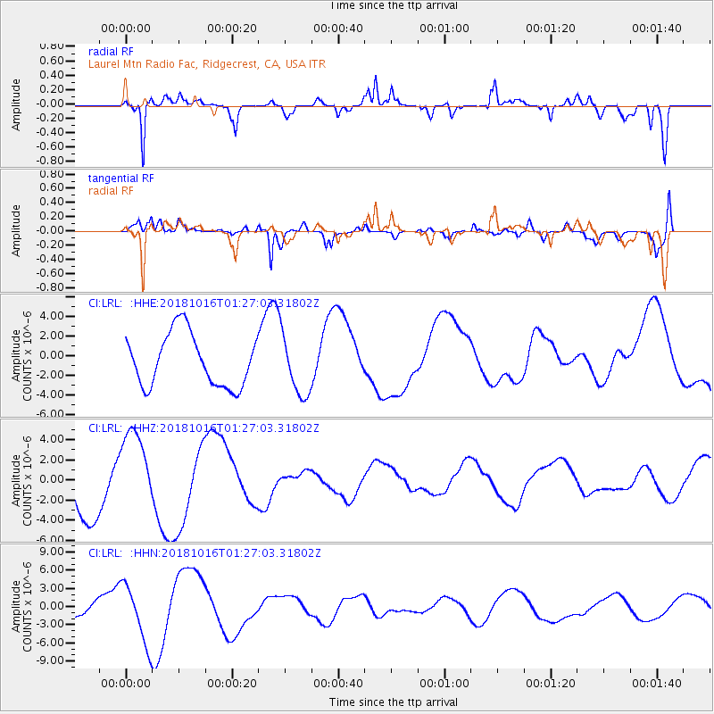
LRL Laurel Mtn Radio Fac, Ridgecrest, CA, USA - Earthquake Result Viewer
*The percent match for this event was below the threshold and hence no stack was calculated.
| Earthquake location: |
Southeast Of Loyalty Islands |
| Earthquake latitude/longitude: |
-21.8/169.4 |
| Earthquake time(UTC): |
2018/10/16 (289) 01:14:37 GMT |
| Earthquake Depth: |
10 km |
| Earthquake Magnitude: |
5.8 Mww |
| Earthquake Catalog/Contributor: |
NEIC PDE/us |
|
| Network: |
CI Caltech Regional Seismic Network |
| Station: |
LRL Laurel Mtn Radio Fac, Ridgecrest, CA, USA |
| Lat/Lon: |
35.48 N/117.68 W |
| Elevation: |
1340 m |
|
| Distance: |
89.5 deg |
| Az: |
51.289 deg |
| Baz: |
242.674 deg |
| Ray Param: |
$rayparam |
*The percent match for this event was below the threshold and hence was not used in the summary stack. |
|
| Radial Match: |
79.70675 % |
| Radial Bump: |
363 |
| Transverse Match: |
67.68128 % |
| Transverse Bump: |
400 |
| SOD ConfigId: |
13570011 |
| Insert Time: |
2019-05-01 13:29:27.682 +0000 |
| GWidth: |
2.5 |
| Max Bumps: |
400 |
| Tol: |
0.001 |
|
Signal To Noise
| Channel | StoN | STA | LTA |
| CI:LRL: :HHZ:20181016T01:27:03.31802Z | 1.187256 | 4.082926E-6 | 3.4389602E-6 |
| CI:LRL: :HHN:20181016T01:27:03.31802Z | 3.924838 | 4.892728E-6 | 1.2466063E-6 |
| CI:LRL: :HHE:20181016T01:27:03.31802Z | 1.1420047 | 3.0417204E-6 | 2.663492E-6 |
| Arrivals |
| Ps | |
| PpPs | |
| PsPs/PpSs | |


