You are here: Home > Network List > TS - TERRAscope (Southern California Seismic Network) Stations List
> Station BAR Barrett Dam, California, USA > Earthquake Result Viewer
BAR Barrett Dam, California, USA - Earthquake Result Viewer
| Earthquake location: |
Southern Bolivia |
| Earthquake latitude/longitude: |
-22.0/-65.7 |
| Earthquake time(UTC): |
1997/01/23 (023) 02:15:22 GMT |
| Earthquake Depth: |
276 km |
| Earthquake Magnitude: |
6.4 MB, 7.1 UNKNOWN, 7.1 MW |
| Earthquake Catalog/Contributor: |
WHDF/NEIC |
|
| Network: |
TS TERRAscope (Southern California Seismic Network) |
| Station: |
BAR Barrett Dam, California, USA |
| Lat/Lon: |
32.68 N/116.67 W |
| Elevation: |
548 m |
|
| Distance: |
73.0 deg |
| Az: |
316.764 deg |
| Baz: |
131.077 deg |
| Ray Param: |
0.052533735 |
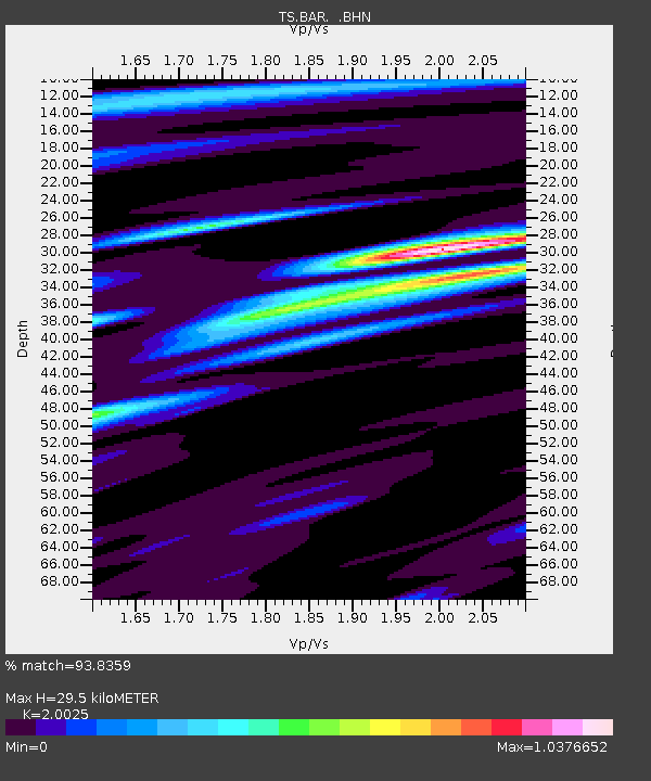
| Estimated Moho Depth: |
29.5 km |
| Estimated Crust Vp/Vs: |
2.00 |
| Assumed Crust Vp: |
6.264 km/s |
| Estimated Crust Vs: |
3.128 km/s |
| Estimated Crust Poisson's Ratio: |
0.33 |
|
| Radial Match: |
93.8359 % |
| Radial Bump: |
339 |
| Transverse Match: |
78.36362 % |
| Transverse Bump: |
400 |
| SOD ConfigId: |
6273 |
| Insert Time: |
2010-02-26 13:59:02.532 +0000 |
| GWidth: |
2.5 |
| Max Bumps: |
400 |
| Tol: |
0.001 |
|
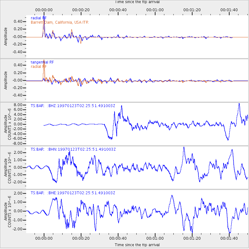
Signal To Noise
| Channel | StoN | STA | LTA |
| TS:BAR: :BHN:19970123T02:25:51.491003Z | 4.2201915 | 5.552109E-7 | 1.3156058E-7 |
| TS:BAR: :BHE:19970123T02:25:51.491003Z | 4.099317 | 5.650312E-7 | 1.3783544E-7 |
| TS:BAR: :BHZ:19970123T02:25:51.491003Z | 8.169202 | 1.6936463E-6 | 2.073209E-7 |
| Arrivals |
| Ps | 4.9 SECOND |
| PpPs | 14 SECOND |
| PsPs/PpSs | 19 SECOND |


