You are here: Home > Network List > IU - Global Seismograph Network (GSN - IRIS/USGS) Stations List
> Station WVT Waverly, Tennessee, USA > Earthquake Result Viewer
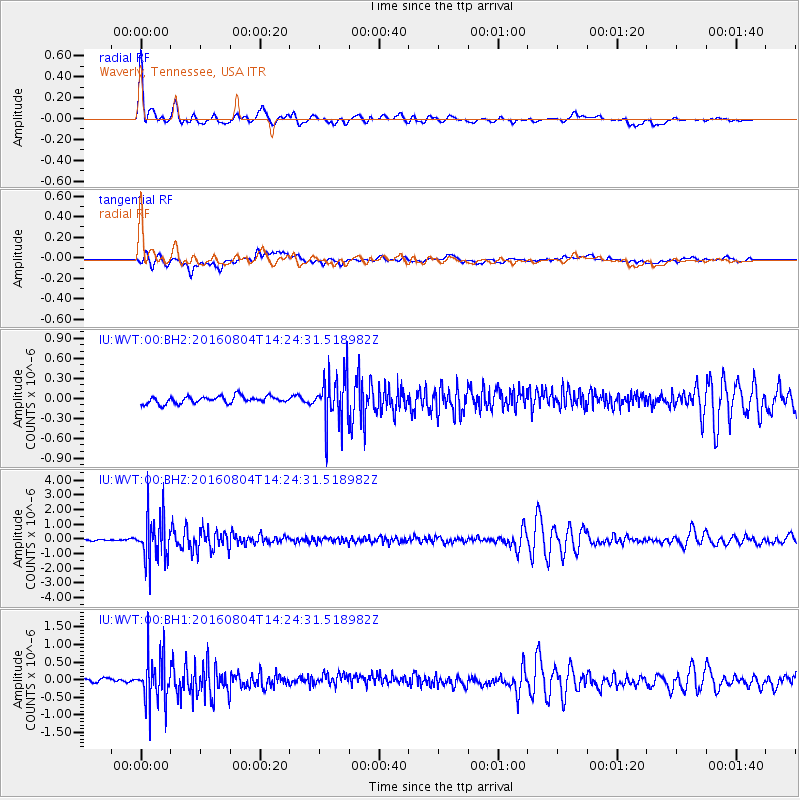
WVT Waverly, Tennessee, USA - Earthquake Result Viewer

| Earthquake location: |
Jujuy Province, Argentina |
| Earthquake latitude/longitude: |
-22.4/-66.0 |
| Earthquake time(UTC): |
2016/08/04 (217) 14:15:11 GMT |
| Earthquake Depth: |
258 km |
| Earthquake Magnitude: |
6.0 MO |
| Earthquake Catalog/Contributor: |
NEIC PDE/NEIC ALERT |
|
| Network: |
IU Global Seismograph Network (GSN - IRIS/USGS) |
| Station: |
WVT Waverly, Tennessee, USA |
| Lat/Lon: |
36.13 N/87.83 W |
| Elevation: |
170 m |
|
| Distance: |
61.8 deg |
| Az: |
340.012 deg |
| Baz: |
156.997 deg |
| Ray Param: |
0.05983821 |
| Estimated Moho Depth: |
51.75 km |
| Estimated Crust Vp/Vs: |
1.71 |
| Assumed Crust Vp: |
6.444 km/s |
| Estimated Crust Vs: |
3.774 km/s |
| Estimated Crust Poisson's Ratio: |
0.24 |
|
| Radial Match: |
90.59116 % |
| Radial Bump: |
400 |
| Transverse Match: |
68.40266 % |
| Transverse Bump: |
400 |
| SOD ConfigId: |
1634031 |
| Insert Time: |
2016-08-18 14:18:03.556 +0000 |
| GWidth: |
2.5 |
| Max Bumps: |
400 |
| Tol: |
0.001 |
|
Signal To Noise
| Channel | StoN | STA | LTA |
| IU:WVT:00:BHZ:20160804T14:24:31.518982Z | 18.771574 | 1.5503064E-6 | 8.258798E-8 |
| IU:WVT:00:BH1:20160804T14:24:31.518982Z | 6.926458 | 6.866633E-7 | 9.9136294E-8 |
| IU:WVT:00:BH2:20160804T14:24:31.518982Z | 6.8028955 | 3.660241E-7 | 5.380416E-8 |
| Arrivals |
| Ps | 5.9 SECOND |
| PpPs | 21 SECOND |
| PsPs/PpSs | 27 SECOND |


