You are here: Home > Network List > TA - USArray Transportable Network (new EarthScope stations) Stations List
> Station F21K Alatna River, AK, USA > Earthquake Result Viewer
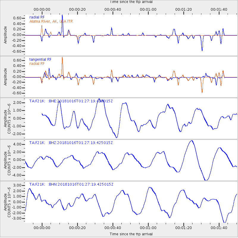
F21K Alatna River, AK, USA - Earthquake Result Viewer
*The percent match for this event was below the threshold and hence no stack was calculated.
| Earthquake location: |
Southeast Of Loyalty Islands |
| Earthquake latitude/longitude: |
-21.8/169.4 |
| Earthquake time(UTC): |
2018/10/16 (289) 01:14:37 GMT |
| Earthquake Depth: |
10 km |
| Earthquake Magnitude: |
5.8 Mww |
| Earthquake Catalog/Contributor: |
NEIC PDE/us |
|
| Network: |
TA USArray Transportable Network (new EarthScope stations) |
| Station: |
F21K Alatna River, AK, USA |
| Lat/Lon: |
67.22 N/153.48 W |
| Elevation: |
597 m |
|
| Distance: |
93.0 deg |
| Az: |
13.618 deg |
| Baz: |
214.185 deg |
| Ray Param: |
$rayparam |
*The percent match for this event was below the threshold and hence was not used in the summary stack. |
|
| Radial Match: |
58.780193 % |
| Radial Bump: |
400 |
| Transverse Match: |
57.759754 % |
| Transverse Bump: |
400 |
| SOD ConfigId: |
13570011 |
| Insert Time: |
2019-05-01 13:31:19.946 +0000 |
| GWidth: |
2.5 |
| Max Bumps: |
400 |
| Tol: |
0.001 |
|
Signal To Noise
| Channel | StoN | STA | LTA |
| TA:F21K: :BHZ:20181016T01:27:19.425015Z | 0.73261434 | 1.0060735E-6 | 1.3732648E-6 |
| TA:F21K: :BHN:20181016T01:27:19.425015Z | 0.1798915 | 4.588679E-7 | 2.5508039E-6 |
| TA:F21K: :BHE:20181016T01:27:19.425015Z | 2.3178115 | 2.033506E-6 | 8.7733883E-7 |
| Arrivals |
| Ps | |
| PpPs | |
| PsPs/PpSs | |


