You are here: Home > Network List > TA - USArray Transportable Network (new EarthScope stations) Stations List
> Station G16K Koyuk River, AK, USA > Earthquake Result Viewer
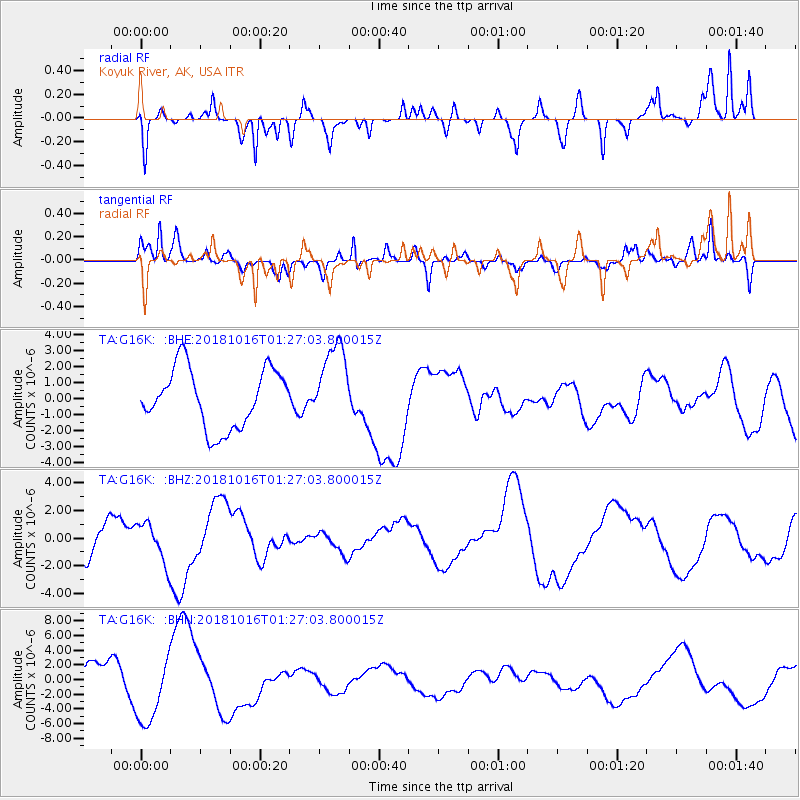
G16K Koyuk River, AK, USA - Earthquake Result Viewer
*The percent match for this event was below the threshold and hence no stack was calculated.
| Earthquake location: |
Southeast Of Loyalty Islands |
| Earthquake latitude/longitude: |
-21.8/169.4 |
| Earthquake time(UTC): |
2018/10/16 (289) 01:14:37 GMT |
| Earthquake Depth: |
10 km |
| Earthquake Magnitude: |
5.8 Mww |
| Earthquake Catalog/Contributor: |
NEIC PDE/us |
|
| Network: |
TA USArray Transportable Network (new EarthScope stations) |
| Station: |
G16K Koyuk River, AK, USA |
| Lat/Lon: |
65.39 N/162.35 W |
| Elevation: |
169 m |
|
| Distance: |
89.6 deg |
| Az: |
11.44 deg |
| Baz: |
206.115 deg |
| Ray Param: |
$rayparam |
*The percent match for this event was below the threshold and hence was not used in the summary stack. |
|
| Radial Match: |
62.76467 % |
| Radial Bump: |
276 |
| Transverse Match: |
46.022736 % |
| Transverse Bump: |
309 |
| SOD ConfigId: |
13570011 |
| Insert Time: |
2019-05-01 13:31:21.864 +0000 |
| GWidth: |
2.5 |
| Max Bumps: |
400 |
| Tol: |
0.001 |
|
Signal To Noise
| Channel | StoN | STA | LTA |
| TA:G16K: :BHZ:20181016T01:27:03.800015Z | 1.1595671 | 1.4436342E-6 | 1.2449769E-6 |
| TA:G16K: :BHN:20181016T01:27:03.800015Z | 1.8851815 | 4.691618E-6 | 2.4886822E-6 |
| TA:G16K: :BHE:20181016T01:27:03.800015Z | 1.388571 | 2.538845E-6 | 1.8283868E-6 |
| Arrivals |
| Ps | |
| PpPs | |
| PsPs/PpSs | |


