You are here: Home > Network List > TA - USArray Transportable Network (new EarthScope stations) Stations List
> Station J26L Joseph Creek, AK, USA > Earthquake Result Viewer
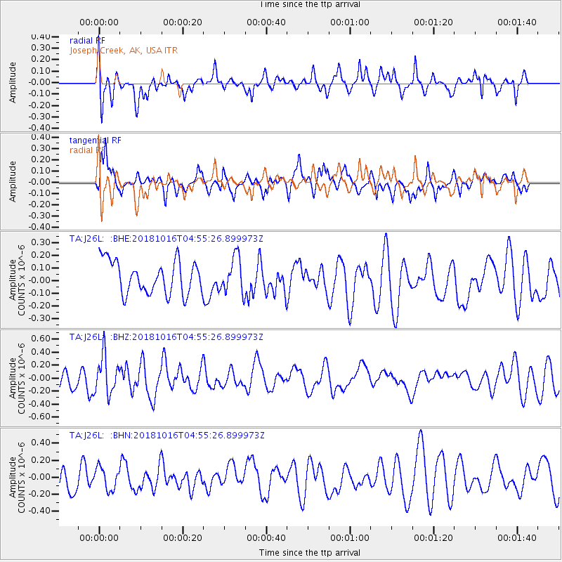
J26L Joseph Creek, AK, USA - Earthquake Result Viewer
*The percent match for this event was below the threshold and hence no stack was calculated.
| Earthquake location: |
Southeast Of Loyalty Islands |
| Earthquake latitude/longitude: |
-21.9/169.4 |
| Earthquake time(UTC): |
2018/10/16 (289) 04:42:42 GMT |
| Earthquake Depth: |
10 km |
| Earthquake Magnitude: |
5.6 Mww |
| Earthquake Catalog/Contributor: |
NEIC PDE/us |
|
| Network: |
TA USArray Transportable Network (new EarthScope stations) |
| Station: |
J26L Joseph Creek, AK, USA |
| Lat/Lon: |
64.50 N/143.56 W |
| Elevation: |
1144 m |
|
| Distance: |
93.4 deg |
| Az: |
18.493 deg |
| Baz: |
222.886 deg |
| Ray Param: |
$rayparam |
*The percent match for this event was below the threshold and hence was not used in the summary stack. |
|
| Radial Match: |
58.026962 % |
| Radial Bump: |
400 |
| Transverse Match: |
57.348934 % |
| Transverse Bump: |
400 |
| SOD ConfigId: |
13570011 |
| Insert Time: |
2019-05-01 13:36:37.069 +0000 |
| GWidth: |
2.5 |
| Max Bumps: |
400 |
| Tol: |
0.001 |
|
Signal To Noise
| Channel | StoN | STA | LTA |
| TA:J26L: :BHZ:20181016T04:55:26.899973Z | 1.9796878 | 2.933591E-7 | 1.4818453E-7 |
| TA:J26L: :BHN:20181016T04:55:26.899973Z | 1.0417405 | 1.340941E-7 | 1.2872121E-7 |
| TA:J26L: :BHE:20181016T04:55:26.899973Z | 1.1284996 | 1.4574479E-7 | 1.2914917E-7 |
| Arrivals |
| Ps | |
| PpPs | |
| PsPs/PpSs | |


